
_england_NIC_2548_stitch.jpg)
The deep river valley, with an entrance that forms an almost land-locked estuary, offers complete protection that is the best the bay has to offer. Although the entrance is fringed by several dangers they are all well marked by lighted buoys and leading lights that make approaches straightforward at all stages of the tide, day or night. However, the upper river's marks are not lit and daylight is required for navigation.

Keyfacts for Dittisham & The River Dart
Facilities


Nature


Considerations

Protected sectors

Approaches

Shelter
Last modified
January 28th 2019 Summary
A completely protected location with safe access.Facilities
Nature
Considerations
Position and approaches

Expand to new tab or fullscreen
Haven position
 50° 22.887' N, 003° 35.591' W
This is the position of the DHNA visitor mooring buoys at Dittisham.
What is the initial fix?
The following Dartmouth Harbour Initial Fix will set up a final approach:
 50° 19.616' N, 003° 32.923' W


What are the key points of the approach?
Offshore details are available in southwestern England’s coastal overview from Portland Bill to Start Point 
- and the River Dart approaches are covered in the Dartmouth Harbour
- Dittisham Lake has two navigable channels separated by Flat Owers, the westernmost being available at all tides.
- Keep to High Gurrow and Blackness Points above Dittisham Lake favouring the port hand shore.
- Then cross over to the northern side of the river at Pighole and Mill Points to favour the starboard shore.
- Alter course to cross the river and favour the port shore after passing between White Rock and the Stoke Point buoy making for buoys off Langham Wood Point.
- Above this the channel narrows and meanders but is simply navigated by following the ample buoys and beacons that lead to Totnes.
 entry.
- Keep to the east bank between Noss Point and Ned’s Point above the Anchor Stone.
Not what you need?
Click the 'Next' and 'Previous' buttons to progress through neighbouring havens in a coastal 'clockwise' or 'anti-clockwise' sequence. Below are the ten nearest havens to Dittisham & The River Dart for your convenience.
Ten nearest havens by straight line charted distance and bearing:
- Dartmouth Harbour - 2.6 nautical miles SSE
- Paignton - 3.4 nautical miles NNE
- Brixham - 3.4 nautical miles ENE
- Torquay - 5.2 nautical miles NNE
- Hope Cove (Tor Bay) - 6.4 nautical miles NE
- Anstey’s Cove - 6.7 nautical miles NNE
- Babbacombe Bay - 6.8 nautical miles NNE
- Watcombe Cove - 7.5 nautical miles NNE
- Hallsands - 9.2 nautical miles SSW
- Kingsbridge - 9.3 nautical miles SW
These havens are ordered by straight line charted distance and bearing, and can be reordered by compass direction or coastal sequence:
- Dartmouth Harbour - 2.6 miles SSE
- Paignton - 3.4 miles NNE
- Brixham - 3.4 miles ENE
- Torquay - 5.2 miles NNE
- Hope Cove (Tor Bay) - 6.4 miles NE
- Anstey’s Cove - 6.7 miles NNE
- Babbacombe Bay - 6.8 miles NNE
- Watcombe Cove - 7.5 miles NNE
- Hallsands - 9.2 miles SSW
- Kingsbridge - 9.3 miles SW

Chart

What's the story here?
 Lower Dittisham
Image: Michael Harpur
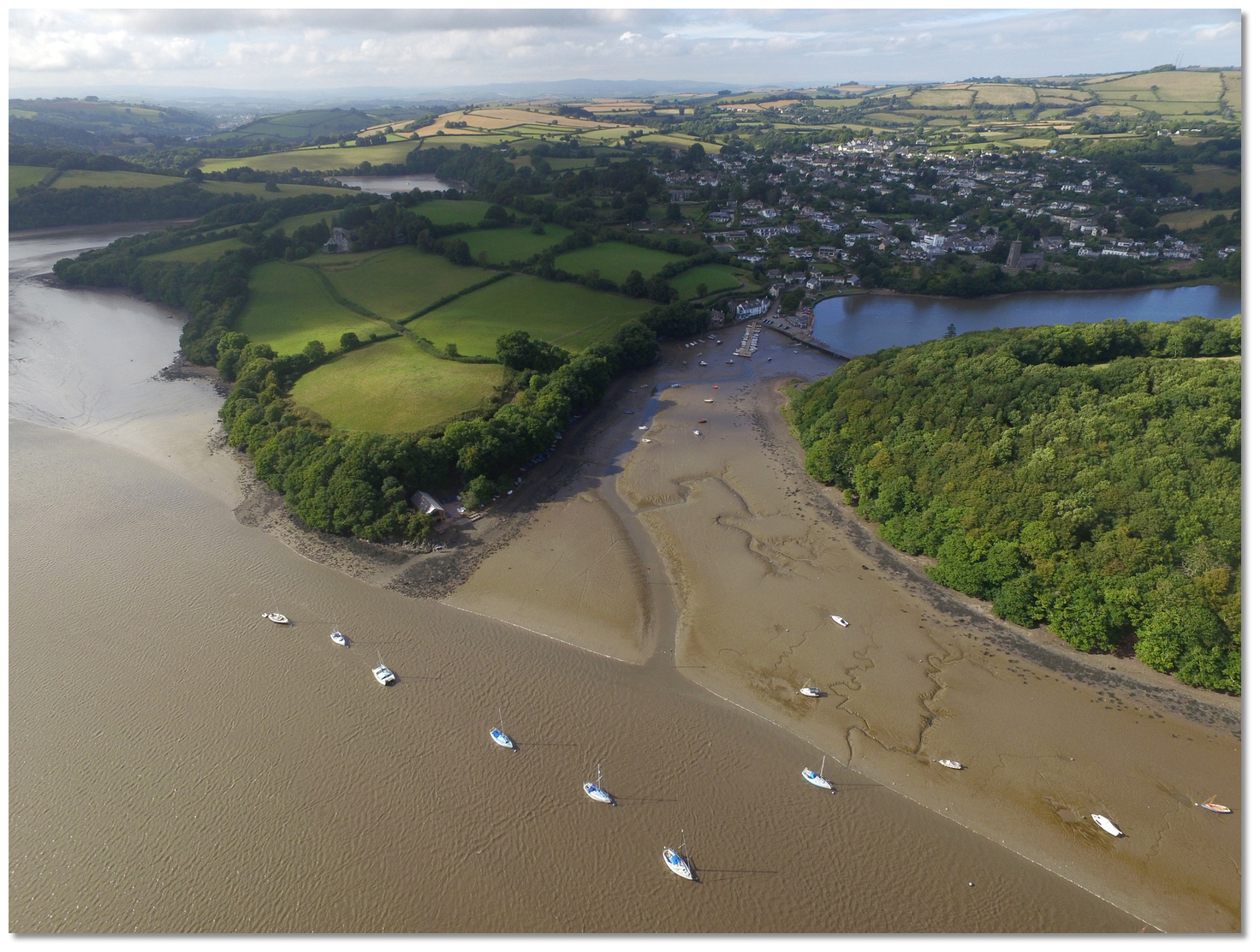
The River Dart exits into the sea 7½ miles northeast of Start Point and 5 miles southwest by west of Berry Head. The entrance forms an almost land-locked estuary and within this is the deep water Dartmouth Harbour that has a long history of maritime usage. Above the extensive Dartmouth Harbour, the long narrow tidal river is navigable for nearly 10 miles inland as far as the old weir a the Elizabethan town of Totnes. Dittisham, situated three miles upriver, has ample water all the way and it can be reached at any state of the tide but Totnes, six miles further inland, requires the half-flood and it dries at low water. The weir at Totnes is the effective end of navigation as above this the river is navigable only to small craft such as kayaks and canoes.
Vessels will find depths of 5 metres at the north end of Dartmouth Harbour and in excess of 10 metres in the centre of the fairway up to Dittisham. The river almost dries out for 2 miles below Totnes at spring tide low water, but vessels drawing up to 1 metre can proceed to Totnes at LW +0130. 2.3 to 3.5 metres is available at Totnes at high water with ample depths along the way.
All berthing in Dartmouth Harbour and along the River Dart area is controlled by the Dart Harbour and Navigation Authority (DHNA) whose role is to make leisure visits to the area as pleasant and trouble-free as possible. There is no berthing without permission of the Harbour Master and wherever you berth, even in the private marinas, all vessels have to pay the harbour dues which are (2018) 85p per metre, per day, on all vessels except those under 4 metres.
Arrivals should contact Dart Harbour by VHF to arrange to berth. The DHNA may be contacted on
 Ch. 11 [DARTNAV],
  +44 1803 832337/833767 ,
  www.dartharbour.org,
  info@dartharbour.org. For urgent issues out of hours please call the duty Harbour Master on
  +44 7968 839846. If you intend to stay for more than 14 days please make the Harbour Office aware of that straight away.
 All DHNA berths are available on a strict first come first served basis and may not be available at certain times due to maritime events. For a small additional fee, the DHNA may accept an advance booking.
 DHNA Dittisham Swing Moorings
Image: Michael Harpur
The maximum holding capacity is stated on the buoy in terms of LOAs and during busy periods expect rafting of two suitable sized vessels per buoy. Each buoy is white with black ‘V’. Call Dart Harbour on VHF Channel 11 [DARTNAV] for permission or with any questions and then berth on the nearest buoy appropriate to the vessel’s length.
Mono-hull: £0.85 per metre per day Multi-hull: £1.20 per metre per day
 DHNA Stoke Gabriel Swing Moorings
Image: Michael Harpur
They are white mooring buoys with a black ‘V’ and LOA rating. Vessels that can take to the bottom may be able to anchor here under advisement from the DHNA.
Mono-hull: £0.85 per metre per day
The river has several anchoring opportunities. Care may be required when the river gets busy to find the right depth clear of other anchored vessels or boats on moorings. Neap tides are a help when one has to work into the margins.
 The river's most popular anchorage below the Anchor Stone
 Image: Michael Harpur
- • The most popular anchoring area is immediately south of Anchor Stone and off Parson's Mud clear of moorings and out of the fairway. Stay west of a line between the rock beacon and the first mooring downstream to remain outside of the main channel. Be careful not to come up on Parson's Mud which is very steep too.
- • Between Dittisham Mill Creek and Blackness Point, again marked by a red beacon. There is mooring tackle laid upstream that should be avoided and if you are in any way uncertain use a trip line. Good depths, in excess of 3 metres, will be found here with good mud holding. Tides, however, run strong and the anchorage is not good in strong northerly winds as it can be exposed to an extensive fetch.
- • Off Bow Creek in deepwater without obstructing the main channel. Again good depths are available here with excellent mud holding
- • In Sharpham Reach without obstructing the main channel between the boathouse and the No. 9 port buoy.
If your vessel can take to the bottom there is a wide range of wonderful locations where it is possible to dry. The primary options are as follows:
 Greenway Quay
Image: Michael Harpur
Details are available from the Harbour Office, River Officer or the ferryman at Dittisham on VHF Ch. 10, [Greenway Ferry] or P: +44 1803 882811.
 Stoke Gabriel
Image: Michael Harpur
Vessels that can take to the bottom may also be able to anchor at Stoke Gabriel under the advisement from the DHNA.
 The Malsters Arms Quay
Image: Michael Harpur
Mooring piles, a planking system, electrical hook-up and water have recently been installed. They have a pontoon for visiting tenders. There is no charge for drying out overnight (2019) but the pub asks for a £5 donation to the RNLI.
 Totnes with the Baltic Wharf pontoon left and Totnes Quay right
Image: Michael Harpur
This facility is owned by South Hams District Council which permits vessels to stay up to 7 days. Directions are posted on the quay giving details of payment and use of these facilities.
 Steam Packet Inn
Image: Phil Gayton via CC BY 2.0
The Baltic Wharf Boatyard, to port, is privately owned but enquire at the office, P: + 44 1803 867922, for visitor berth availability. Berthing at privately owned Steamer Quay and Town Quay is not permitted but passengers may land and embark at the public steps there. It is possible to go upriver to where the river forks to a single berth at the terrace of the Steam Packet Inn on St. Peter's Quay. Make berthing arrangements in advance P: +44 1803 863880.
 Totnes Boating Association moorings beneath the bridge
Image: Michael Harpur
The main channel continues up to Totnes where the Totnes Boating Association clubhouse can be seen on the right bank. The club has its own moorings but if enquiries are made at the clubhouse they may be able to provide a spare mooring.
How to get in?
 The River Dart at Dittsham
Image: Michael Harpur
 Use southwestern England’s coastal overview from Portland Bill to Start Point and the River Dart approaches are covered in the Dartmouth Harbour entry.
Standard river practice should then be adopted in the River Dart which increasingly meanders the further inland it penetrates. Keep to the outside of bends, where the faster flow of the river erodes deeper water and out of the inside curves where the slow-moving water deposits some load, forming a river beach or slip-off slopes. Boat speed in the River Dart and its resultant wash should be kept to an absolute minimum.
 Higher Noss Point and Noss-On-Dart Marina
Image: Michael Harpur
Above Higher Noss Point the river deepens providing a least charted depth of 10.8 metres in the centre of the fairway as far as Dittisham. Upper Noss Creek marks the start of one of the most tranquil and unspoilt sections of the river, which, between here and Dittisham, is characterised by thickly wooded hillsides. For this leg of the voyage, as far as Ned’s Point situated about a mile upriver beyond the Anchor Stone, the channel hugs the east bank.
 The Anchor Stone rock with a large red topmark atop
Image: Jonathan Billinger via CC BY-SA 2.0
The key danger to identify is the Anchor Stone which is marked by a red pole with a red can topmark Fl(2).R.5s. Leave this danger well to port. The DHNA Dittisham swinging visitors’ moorings are located just beyond the Anchor Stone, on the west side of the river and just below Dittisham that is situated on the west bank.
 Dittisham Lake
Image: Michael Harpur
At Dittisham the bustling marine activity is again in evidence. The river widens here to the ½ mile wide Dittisham Lake that has two navigable channels separated by the Flat Owers shoal that dries 2 metres. It is advisable that vessels proceeding further upriver do so on a rising tide from here on. Those electing to continue upriver have two options to circumvent the Flat Owers shoal:
 The 'Flat Owers’ buoy and the positions of the two successive boathouses
Image: Michael Harpur
 Waddeton Boathouse
Image: Michael Harpur
First, a bearing of 020° T of Waddeton Boathouse which passes just over 50 metres to port of the buoy.
 Sandridge Boathouse
Image: Michael Harpur
Then, when past the ‘Flat Owers’ buoy, realign on on a bearing of 310° T of the Sandridge Boathouse on the north shore until the river again deepens. Some unlit racing marks may be encountered off Lower Gurrow Point.
 Dittisham Mill Creek and Blackness Point
Image: Michael Harpur
In either case when within 100 metres of Sandridge Boathouse turn south-westward towards the centre of Dittisham Mill Creek favouring the shore on the port side of the boat and drawing abeam of Higher Gurrow Point.
 Blackness Point as seen from upriver
Image: Michael Harpur
Then alter course to starboard and steer for Blackness Point beacon, unlit, comprising a red pole with a red can topmark. Leave this well to port and steer to pass 100 metres north of Blackness Point.
 Mill Point to High Gurrow Point as seen from the southern shore
Image: Michael Harpur
When Blackness Point is abeam, steer for the Pighole Point unlit lateral port marker buoy passing it to port. On reaching Pighole Point switch to favour the shore on the starboard side of the boat.
 The Long Stream with Pighole and Blackness Points in the backdrop
Image: Michael Harpur
The best water is now to be found in the Long Stream northwest of Pighole Point. Keep about 80 metres off the shore until about halfway between the Pighole Point port marker and the Long Stream port marker in the moorings off Stoke Gabriel.
 Stoke Gabriel
 Image: Michael Harpur
The DHNA visitors' buoys are set before the red and green beacons that mark the entrance to Stoke Gabriel. The channel to Stoke Gabriel meanders to the port bank then over to starboard of the dinghy pontoon. It’s possible to tie-up on the quay beyond the pontoon, but most people moor outside and dinghy in.
 White Rock on the southern shore
Image: Michael Harpur
Pass Stoke Gabriel and Mill Point close to starboard and then the best water can be found by altering course to cross the river and favour the shore on the port side of the boat. Continue between White Rock and the Stoke Point starboard lateral buoy. Then follow the course of the southern shore making for the buoys off Langham Wood Point that mark the entrance to Bow Creek. A good deep-water anchorage with excellent mud holding can be had close southeast of the 'Bow Creek' port buoy.
 Stoke Point to White Rock, the entrance to Bow Creek and Langham Wood Point
Image: Michael Harpur
The top of the tributary of Bow Creek offers the Malsters Arms at Tuckenhay. Based on a 4.6-metre tide, boats drawing up to 1 metre can reach the quay fronting the inn ±2:30 of high water. The channel is marked by posts and buoys which wind in intricate 'S' shapes for ¾ of a mile to the pub.
 The Malsters Arms Bow Creek
Image: Michael Harpur
 The winding Upper Dart
Image: Edwardsian via CC ASA 4.0
Anchor or pick up moorings along the river, anchor off or dry out as required. Land by tender at Dittisham Pontoon at the clearly marked area at the end of the Dittisham pontoon. There is also a pontoon at Stoke Gabriel. Both of these pontoons allow berthing of tenders no larger than 4.3 metres for up to 6 hours.  Dittisham pontoon a short tender ride from the visitor moorings
Image: Michael Harpur
The Dittisham to Greenway Ferry is based on Greenway jetty upon the opposite shore. The jetty is private but the owner can be contacted by calling the ferry on VHF Ch. 10 for permission to land.
Why visit here?
The River Dart has been a historical Devon trading highway through the ages. It reputedly saw Phoenician galleys ply their way through its waters and it is believed that Brutus, of ‘Et Tu?’ Julius Caesar fame, sailed up the river and upon landing near its head said ‘Here I stand and here I rest and this place shall be called Totnes.’ The River Dart at Duncannon Reach
Image: Michael Harpur
When the first wave of the Saxon invasions of England came to Devon in 660 A.D., a Saxon Chief called Deedas led a group of his kin up the well-established fairway to Dittisham. Here he made his home giving the area his name Deedas combined with the old English ‘ham’, meaning homestead of 'Deedas' although locally pronounced Dit’sum. The attraction of the location is made clear by it being one of the very earliest Saxon settlements in Devon. It took another century, until 755 A.D., for the Saxons to finally conquer the remaining Celtic tribes, or old ‘Britons’, of Devon. Some of these chose to flee by sailing across the Channel to France instead of being overrun, where they would eventually be known as ‘Bretons’.
 Dittisham as seen from upriver above Langham Wood Point
Image: Michael Harpur
Although originally pagan the Saxons would convert to Christianity and a church was recorded as being in existance at Dittisham in 1055. At the death of Edward the Confessor, on 5th January 1066, Dittisham Manor was held by Bishop Leofric. In 1088 Domesday records the village as 'Didashim as having a church and 22 villagers which normally indicates a number of families with a population of more than 100. From that time on Dittisham was a peaceful abode that was lightly touched by the hand of time. It remained a small river settlement which is today home to a population of about 400. Though it has been a haven of tranquility, it has been home to some historically notable people who have for the most lived in Greenway House, just across the river.
 Pretty houses in Dittisham
Image: Michael Harpur
Sir Humphrey Gilbert, 1539-1583, was born at Greenway and his half-brother, Sir Walter Raleigh, 1552-1618, from his mother’s second marriage, spent much of his time there. In 1583 Sir Humphrey Gilbert failed in his quest to find the Northwest Passage and instead landed at St John's where he formally took possession of Newfoundland for England. The prodigious fishing grounds that this provided transformed the economy of Dartmouth for centuries and the river settlements by extension. His younger half-brother Sir Walter Raleigh would become one of the original explorers of Virginia and went on to establish the first English colony in North America. Again, Dartmouth and the river was well placed to capitalise on the prosperity that the trade with the colonies would provide.
 Greenway House just across the river
Image: Michael Harpur
The Greenway House seen today was not their home but one rebuilt on the original foundations of their house in the Georgian style. In 1926 it became the beloved holiday home of the renowned author Agatha Christie and her family. Although she did not write at the cottage, she did use the grounds as the setting for some of her murders. The village name also made it into one of the main characters of the ‘Five Little Pigs’ in the guise of the fictitious Lady Dittisham. The cottage, its large surrounding grounds, gardens that feature some of her family memorabilia was left to the National Trust and is open to the public from 10.30-17.00 during the season.
 The steep hill leading up to St. George's Church
Image: Michael Harpur
Today, tucked into to a sheltered bend in one of the most picturesque turns of the Dart, and entirely within an Area of Outstanding Natural Beauty, the village is eminently attractive. It has two distinct clusters of buildings, Higher Dittisham around the Parish Church and Lower Dittisham climbing away from the Greenway Ferry crossing of the Dart. Higher Dittisham is exceptionally beautiful and a walk up its steep hill takes you past pretty traditional homes and gardens to the picture perfect church of St George overlooking Dittisham Mill Creek. This dates from 1333 but is mostly a 15th and early 16th-century building, built of the local slate, and contains several items of historic importance.
 St. George Church at Higher Dittisham
Image: Michael Harpur
From a boating perspective, this is sailing at its best and few rivers can match the natural beauty of the Dart. The entrance to the river, guarded by Kingswear and Dartmouth Castles, is exceptionally attractive with its steep rocky shoreline and wooded hillsides. This then opens to reveal the wonderful and historical Dartmouth Harbour in the Lower Dart. Unfortunately, that is as far as many visiting boats get to, but it’s upriver the River Dart really comes into its own.
 The tranquil DHNA moorings off the jetty at Dittisham
Image: Michael Harpur
The sheltered river provides deep water up to unspoilt Ditisham, which is located in one of the most dramatic settings in the South Hams just a couple of miles further up. The village makes for a truly relaxing break with perfect security. In the rivers trading heyday, it reputedly had seven inns and cider houses but the Ferry Boat Inn on the quay and the Red Lion, up the hill near the village shop, will more than meet all your needs today.
 Children enjoying some crabbing from Dittisham pontoon
Image: Michael Harpur
But it is only one of many joys along the Dart that at half-flood provides navigable waters for another six miles inland to the Elizabethan town of Totnes. With the right tide, there is plenty more to explore in the creeks and villages such as Galmpton, Stoke Gabriel and Bow Creek. All the way up you should be in fine company with the river’s natural denizens; cormorants, kingfishers, herons, egrets, curlews, oystercatchers, the occasional seal and, if you are lucky, maybe a family of otters.
What facilities are available?
Ditisham has a limited number of community facilities which include a post office. Excellent provisioning may be had at the sizable town of Totnes which is the administrative centre of the South Hams District Council. It has an excellent range of shops and a twice-weekly market.Slipways are available at Totnes, Steamer Quay, Blackness Marine, Stoke Gabriel and Dittisham.
Across the river, at Galmpton Creek there are several boatyards which can cater for any repairs required for almost any vessel, and has a 65-ton hoist, one of the largest in the area, which operates from a purpose-built dock.
Totnes railway station is situated on the Exeter to Plymouth line, and has trains direct to London Paddington, Plymouth and Penzance, and as far north as Aberdeen. Nearby, Totnes (Riverside) railway station is at the southern end of the South Devon Railway Trust which runs tourist steam locomotives along the line that follows the River Dart up to Buckfastleigh.
With thanks to:
eOceanic_england_River Dart (135).jpg)
Dittisham & The River Dart, Devon, England
Image: eOceanic thanks Michael Harpur
_england_NIC_2499.jpg)
Dittisham Lake
Image: eOceanic thanks Michael Harpur
_england_NIC_2472.jpg)
The view southward towards Anchor Stone
Image: eOceanic thanks Michael Harpur
_england_NIC_2471.jpg)
Glampton Creek opposite with its many boatyards
Image: eOceanic thanks Michael Harpur
_england_NIC_2591.jpg)
Ferryboat Inn above the jetty
Image: eOceanic thanks Michael Harpur
_england_NIC_2595.jpg)
Red Lion near the village shop
Image: eOceanic thanks Michael Harpur
_england_NIC_2628.jpg)
Upper Dittisham's steep street
Image: eOceanic thanks Michael Harpur
_england_NIC_2653.jpg)
Upper Dittisham's steep street leading to St. George's Church
Image: eOceanic thanks Michael Harpur
_england_NIC_2663.jpg)
St. George Church at Higher Dittisham
Image: eOceanic thanks Michael Harpur
_england_River Dart (100).jpg)
The River Dart at Duncannon Reach
Image: eOceanic thanks Michael Harpur
_england_River Dart (102).jpg)
River Dart beacon at Duncannon Reach
Image: eOceanic thanks Michael Harpur
_england_NIC_2127.jpg)
Totnes with the Baltic Wharf pontoon left and Totnes Quay right
Image: eOceanic thanks Michael Harpur
_england_NIC_2115.jpg)
The Baltic Wharf pontoon
Image: eOceanic thanks Michael Harpur
_england_NIC_2114.jpg)
Totnes Council's wooden quay
Image: eOceanic thanks Michael Harpur
_england_NIC_2196.jpg)
Totnes
Image: eOceanic thanks Michael Harpur
Dittisham Aerial Overview


Add your review or comment:
Please log in to leave a review of this haven.
Please note eOceanic makes no guarantee of the validity of this information, we have not visited this haven and do not have first-hand experience to qualify the data. Although the contributors are vetted by peer review as practised authorities, they are in no way, whatsoever, responsible for the accuracy of their contributions. It is essential that you thoroughly check the accuracy and suitability for your vessel of any waypoints offered in any context plus the precision of your GPS. Any data provided on this page is entirely used at your own risk and you must read our legal page if you view data on this site. Free to use sea charts courtesy of Navionics.