
_isle_of_wight_england_HEAD NIC_1123.jpg)
The creek provides good protection in all but strong north round to east winds. The dredged and well-marked ferry channel makes outer access straightforward but beyond it the creek is tidal and new comers should arrive in daylight.


Keyfacts for Wootton Creek (Fishbourne)
Facilities


Nature


Considerations


Protected sectors

Approaches

Shelter
Last modified
August 24th 2018 Summary* Restrictions apply
A good location with straightforward access.Facilities
Nature
Considerations
 +44 1983 882325
 office@rvyc.org.uk
Position and approaches

Expand to new tab or fullscreen
Haven position
 50° 44.086' N, 001° 12.838' W
This is the position of the head the Royal Victoria Yacht Club pontoon.
What is the initial fix?
The following Wooton Creek initial fix will set up a final approach:
 50° 44.540' N, 001° 12.125' W


What are the key points of the approach?
The entry and the run-up thorough The Solent and Southampton Water are covered in
The Solent and Isle of Wight Coastal Overview. Vessels converging on the entrance will find nothing in the way of local hazards by staying in reasonable soundings and following the marks. The direction of buoyage in the eastern Solent is from east to west.
The Solent and Isle of Wight
Coastal Overview. Vessels converging on the entrance will find nothing in the way of local hazards by staying in reasonable soundings and following the marks. The direction of buoyage in the eastern Solent is from east to west. - All dangers may be avoided by staying to the north of Wootton Light Beacon situated off the seaward end of the entrance channel.
- Only approach the entrance channel when it is clear of any possible ferry movement.
- Proceed down the starboard side of the straight ½ mile long channel towards the terminal.
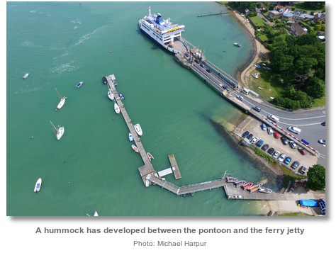
- The drying club pontoon is 100 metres west of the ferry terminal.
Not what you need?
Click the 'Next' and 'Previous' buttons to progress through neighbouring havens in a coastal 'clockwise' or 'anti-clockwise' sequence. Below are the ten nearest havens to Wootton Creek (Fishbourne) for your convenience.
Ten nearest havens by straight line charted distance and bearing:
- Ryde Roads - 1.2 nautical miles ENE
- Osborne Bay - 2.1 nautical miles NW
- Ryde Harbour - 2.3 nautical miles E
- Island Harbour Marine - 2.6 nautical miles WSW
- Folly Inn - 2.6 nautical miles W
- East Cowes Marina - 3.2 nautical miles WNW
- Shepards Wharf - 3.3 nautical miles WNW
- Stokes Bay - 3.4 nautical miles NE
- Newport - 3.4 nautical miles WSW
- Cowes Yacht Haven - 3.5 nautical miles WNW
These havens are ordered by straight line charted distance and bearing, and can be reordered by compass direction or coastal sequence:
- Ryde Roads - 1.2 miles ENE
- Osborne Bay - 2.1 miles NW
- Ryde Harbour - 2.3 miles E
- Island Harbour Marine - 2.6 miles WSW
- Folly Inn - 2.6 miles W
- East Cowes Marina - 3.2 miles WNW
- Shepards Wharf - 3.3 miles WNW
- Stokes Bay - 3.4 miles NE
- Newport - 3.4 miles WSW
- Cowes Yacht Haven - 3.5 miles WNW

Chart

How to get in?
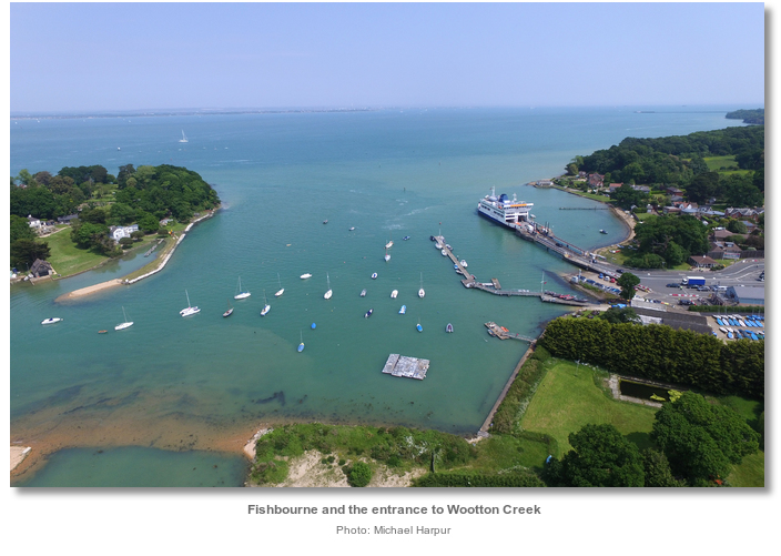
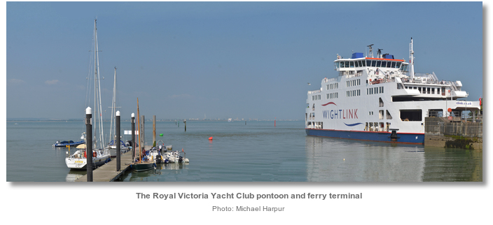
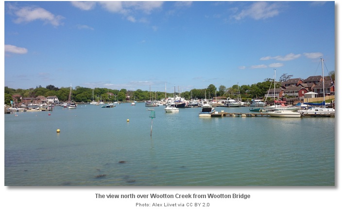
Wootton Creek is a tidal estuary that flows into The Solent on the northeast coast of the Isle of Wight. At the mouth of the estuary is the principal Wightlink car ferry that runs to and from Portsmouth, night and day, and the Queen’s Harbour Master, Portsmouth is the harbour authority. On the creek’s east bank, commencing at the ferry terminal, is the village of Fishbourne and further within on its west bank is the village of Wootton.
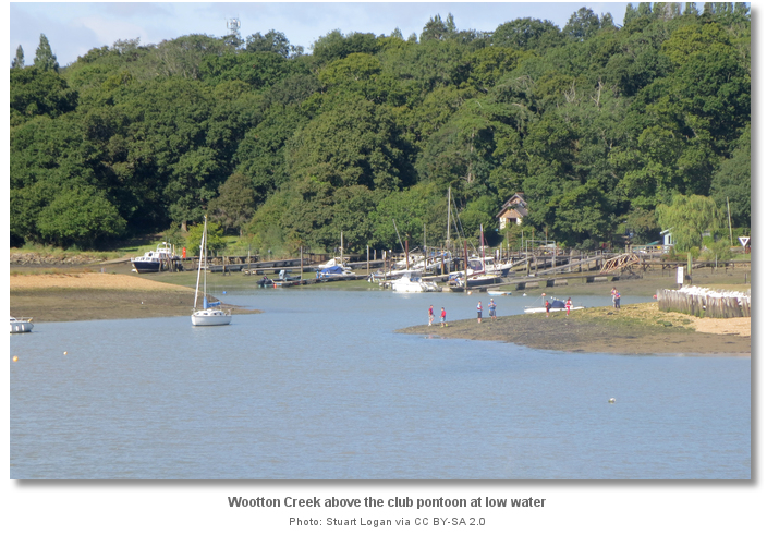
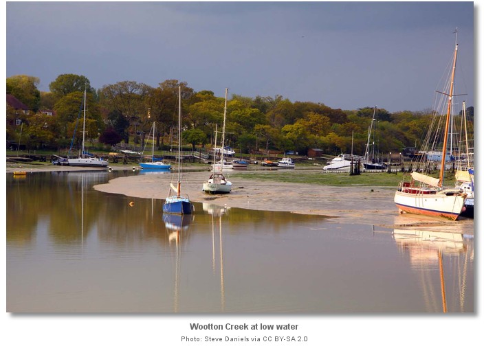
Wootton Creek begins to dry rapidly beyond the channel to the ferry terminal. Its high water navigational limit is Wootton Bridge, ¾ of a mile southwest from the mouth, where the creek attains a drying height of 2.6 metres. The estuary is not navigable beyond Wootton Bridge as the tidal water is enclosed and retained by sluice gates under the bridge.
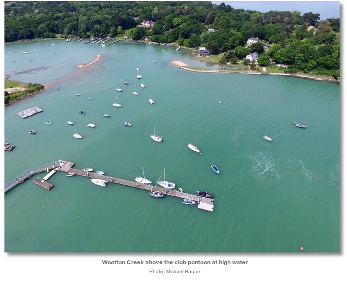
There are no deep visitor moorings in the creek and anchoring in the channel is prohibited. The very friendly Royal Victoria Yacht Club, adjacent to the ferry berth, specifically welcome visitors to their pontoon, which dries at low water. To confirm availability or book a berth contact the club office on P: +44 1983 882325 or E: office@rvyc.org.uk. Club office hours are Monday to Friday 0930 to 1500, Saturday 0930 to 1300 and they are closed on Sunday. Newcomers will find the best time to make their first visit is an hour or so before High Water.
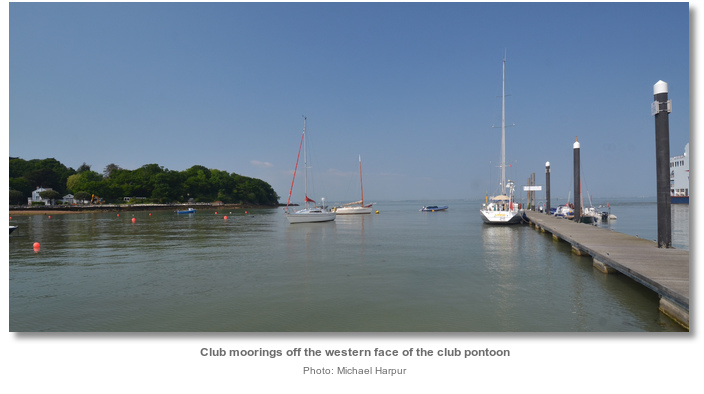
It is also possible to anchor off Wootton Point, outside its outlying Wootton Rocks well clear of the Creek’s entrance and fairway. To the east of the Royal Victoria Yacht Club race box the club has laid two trots of seasonal National Squib moorings. About 2 to 3.6 metres can be found outside of the two trots. However a boat will be tide rode here so it is more ideally suited to light offshore conditions.
Those intending to anchor here should not pick up the club moorings off Wootton Point, or any within the creek itself, as they are all private small boat moorings that could not take the weight of a cruiser. Anchoring is forbidden in the fairway and also not permitted, nor advisable, in the mouth of the creek due to the proliferation of abandoned ground chains and other mooring tackle.
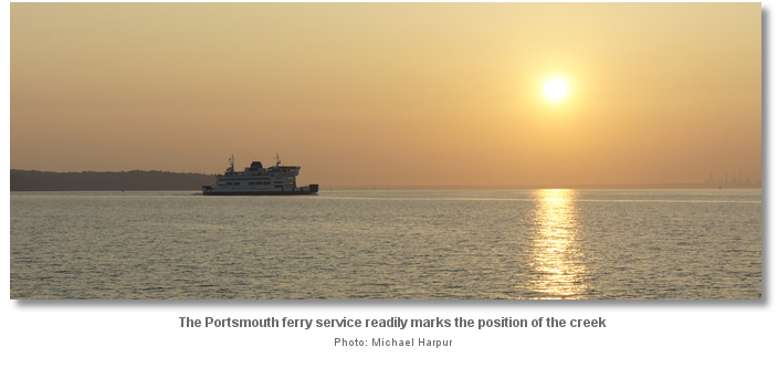
Identification of Wootton Creek and its navigation is made straightforward by its frequent ferry service to Portsmouth Harbour and the well-marked approach channel to the ferry jetty. Depending on the season, the car ferry leaves on the hour, or sometimes the half-hour, from first light until midnight. A ferry may occasionally be seen to be hove-to awaiting a berth out to the west of the fairway and they can at times approach from there outside of the channel.
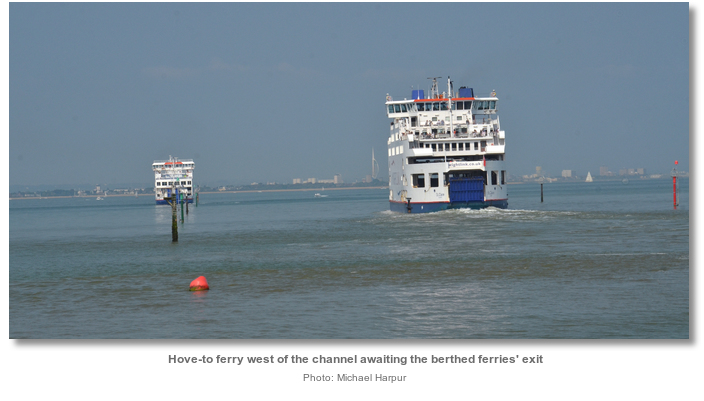
The ferries present the single largest hazard for a final approach. Leisure vessels cannot enter the approach channel at the same time as a ferry is transiting it. There is very little water either side of the fairway and the ferries constrained by their draughts have absolute right of way. This is particularly the case in the fairway’s inshore half, from light beacons No. 2 and 3 inward, where at low water there is little or no room available to pass. The ferries are easily avoided as they typically exit and enter within a 10 minute period. Even when they running on the half hour this provides leisure craft with an interval of about 20 minutes twice an hour in which they can freely come and go through the channel. The best time to enter, or depart, is when the incoming ferry has just berthed.
 The primary hazard for vessels approaching from the east is the great expanse of Ryde Sand that has left many leisure craft standing. Keep its Red Piles at least 200 metres to port approaching Ryde Pier, with its three sets of lights, 2FR (vert) and FY fog. Vessels should then stand well off the pier head so as not to hamper the high-speed ferry service operating from there.
After Ryde Pier Ryde West Sands dry about ¼ of a mile from the shore and the 2.0 metre contour is about ½ a mile out. Steering a course from the head of Ryde pier to Wootton Beacon, the position of the initial fix 1½ miles apart, clears all dangers. Wootton Creek will be made readily apparent by the coming and goings of the Wightlink ferries. On final approaches the substantial piles of the approach channel will be clearly seen.
 The primary hazard for vessels approaching from the west are two wrecks within a designated water-skiing area on the approaches, and the dangerous Wootton Rocks close to the entrance.
 The two wrecks lie inshore of Peel Bank and within the buoyed Wootton Creek water-skiing area. The water-skiing area is centred on unlit Peel Wreck Buoy that is about ¾ of a mile northwest of the approach to Wootton Creek. Steering a course parallel to the shore but outside the water-skiing area, if it is marked, and keeping the Peel Wreck port hand marker buoy to starboard clears both wrecks.
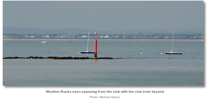
The dangerous Wootton Rocks off the entrance is a ⅓ of a mile long rock ledge, lying east-west, and located about 300 metres northward of the forested Wootton Point. Its position is indicated by an unlit red beacon situated on its north-eastern end.
The Royal Victoria Yacht Club's starting platform, located about 400 metres northward of Wootton Rocks in about 3 metres, is a good safe mark by day but it is not lit at night. The platform is readily identifiable against the wooded shoreline and passing northward of it takes a vessel well clear of the Wootton Rocks.
The piles of the approach channel will be clearly seen long before the start platform is passed.
 The Wootton Creek initial fix is set on the position of the Wootton Light Beacon north cardinal that exhibits a light by night Q.W. Vessels approaching from all directions will find it best to stay to the north of Wootton Light Beacon off the seaward end of the approach channel. It is likewise the best point from which to see if the channel is clear and make an approach.
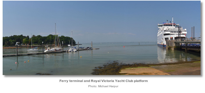
 When the channel is clear of transiting ferries proceed down the western side of the fairway following the ample marks in. At the starboard hand No. 7 beacon, the ferry link-span will be clearly visible to port, the Royal Victoria Yacht Club's pontoon will be seen close west and the Wootton Creek port and starboard entrance buoys, where the deepest water will be found, will be seen off the head of the pontoon. All of which are unmistakable as the fairway’s line of starboard piles, the creek’s port and starboard buoys and the head of the club pontoon are almost in a straight line.
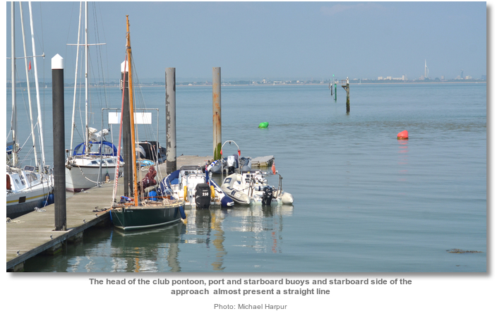
Turn to starboard to bring the yacht club pontoon on to the port side. Vessels should not approach the pontoon through the club’s private moorings located close northwest of the pontoon or pick any of them up.
 The Royal Victoria Yacht Club is situated at the mouth of Wootton Creek next to the Wightlink ferry terminal. It welcomes visiting boats alongside their pontoon. Vessels that can take to the hard can overnight here and it is possible for fin keel boats to come in for a short stay at high water.
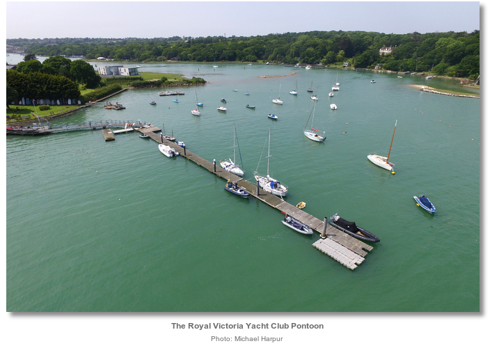
The club pontoon is 100 metres long and has drying heights from 1.3, on the inside portion of the pontoon, to 0.8 metres on the outside. But heights vary depending on the accumulated wash thrown up by the ferries. It is best to expect some tidal flow across the pontoon that occurs at various points of the tide. If vessels are already berthed alongside hail and ask for rafting guidance. On occasions the club manager may ask berthed vessels to move to best accommodate other visitors.
The seaward end section of the pontoon has become privately owned since 2015. The inner club section of the pontoon can be identified by its piles having white caps and an unmistakable bridging notice board separating the sections.
Those intending to dry out may find the bottom alongside the pontoon irregular in shape and consistency. This makes it advisable to watch the vessels taking to the ground on the ebb in case some adjustments of lines and fenders may be required to bed in comfortably.
Pontoon fees can be paid at the club bar or if the club is closed drop it in the letterbox at the side of the club entrance. Pontoon berth charges are (2016) £5 for a short stay, 1 tide, £1.50 per metre for mono hulls overnight and £2.25 per metre for multihulls overnight. Vessels moored on the outer private section may be independently approached for payment by their owners.
Unofficially, available moorings further up the creek may be acquired with the benefit of local knowledge. It may be possible to dry out in Ashlake Creek, set into a bight in the eastern side of the channel about half way to Wootton Bridge, where it dries to 2.8 metres, or just below Wootton Bridge.
Those intending to continue up the creek should keep speeds below 5 knots. The creek's tidal currents are usually benign but they can attain 4 knots just after High Water at Springs and especially so when the sluice gates under Wootton Bridge are opened.
Pass through the creeks port and starboard entrance buoys and align on the leading marks, consisting of a pair of white triangles, situated on the western shore. Continue past a green pile close to starboard, off the western bank, and then a port pile in the centre of the creek that is left close to port. A line of piles, passed to port, then leads towards Fishbourne Quay. After this there is a final starboard green pile, deceptively appearing on the wrong side of the creek, which should be passed on its correct side close to starboard. Above this the best water can be found by taking a midway course up the creek to Wootton Bridge.
Why visit here?
The villages of Fishbourne and Wootton surround Wootton Creek. ‘Wootton’ which is an Old English place name means place or farmstead in a wood whilst the name ‘Fishbourne’, first recorded as Fisseburne in 1267, indicates ‘stream of fish’ or ‘a place where fish are caught’. The names of the two villages that face each other over the sheltered inlet of Wootton Creek Estuary, like many Parishes on the Isle of Wight, indicate a history that is rich, varied and deep.This is particularly the case with Fishbourne where significant numbers of archaeological finds, of national or international importance, have been uncovered on its foreshore. An unexpected consequence of the dredging and deepening of the car ferry channel was to trigger local coastal erosion that stripped sands from Fishbourne beach. This in turn exposed black mud full of complete and semi-complete pots ranging in date from the Iron Age to the medieval period. The finds provided evidence that Fishbourne had settlements that went back to the Iron and Bronze ages. Specific evidence at the mouth of the creek showed that they engaged in fishing as it is thought that stone-age man set up conical fish traps in the streams running out of Wootton. These survive in the form of ‘V’ shaped post groups which probably held the conical baskets.
Long after the Romans departed the area must have continued to be an important trading centre as there are accounts from the year 897 AD that it was raided by a Viking longboat. The Northmen had made their first attack on the Hampshire coast in 835 AD and for the two centuries following the district was the scene of perpetual devastations. The Danish pirates made their headquarters in the Isle of Wight, from which they plundered the opposite coast, and Wooton Creek could have been one of their bases. A Viking style cloak pin was found in the area that dated from the tenth or eleventh century.
The beach went on to be a medieval trading centre where vessels continued to land their cargoes. A large percentage of the mixture of broken cargo from beached vessels and jetsam recovered from the site is of this date and a fair share of this was most likely smuggled materials. As early as 1575 piracy was rampant in the Solent, in 1584 it was noted that "the majority of pirates in this country are between the Isle of Wight and Poole" and the centre of activity was less than two miles to the northwest at Mead Hole; now Osborne Bay. The end of domestic piracy doubtless increased smuggling which by the 18th century had grown to become organized-crime on a very large scale. A parliamentary commission of 1748 estimated that the revenue lost through smuggling was equivalent to the entire revenue of England. Fast cutters built on Wootton Creek, doubtlessly with many of its locals at the helm, found their way into this smuggling activity. Many of the houses in early Fishbourne were built and occupied by coastguards and their families when, when in the late 1700s, it was recorded that there were as many as 121 customs staff at Cowes. Even with the help of the army they were unable to cope with the large armed gangs who had usually vanished by the time the troops arrived.
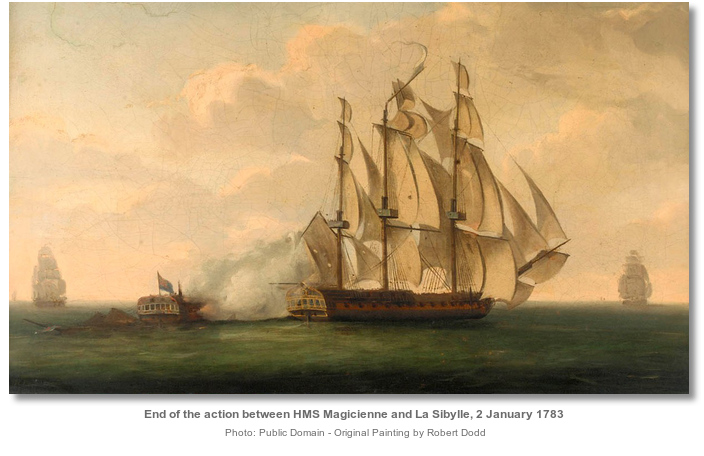
The tradition of shipbuilding remained well rooted in Fishbourne to the middle of the 19th century. This reaching its zenith in the early 19th century when Fishbourne was described at this time as being “of far greater consequence than Cowes”. Surprisingly large Royal Navy ships were constructed here including the frigates Magicienne, Tagus and the Tiger (Tiber). Launched in 1812 and 1813 these vessels were of considerable size, being over 150 ft. long, weighing over 1,000 tons and carrying 36-38 guns. Ships continued to be built here for some time including the very successful Falcon that was a ‘yacht’, best thought of as ‘naval frigate in miniature’, of 351 tons with 20 guns. It was built to demonstrate to the Admiralty what a fast, seaworthy, full-rigged ship should be. But Fishbourne’s ship building days had come to an end by 1840, although smaller craft continued to be built further along the shore. Farming then remained the largest activity although the land around Wootton Creek was never particularly good. In 1813 a general view of the Island’s agriculture described the northeast sector as ‘ . . generally characterised as oak tree, or sour woodland clay. A mill nevertheless plied its trade at Wootton Bridge since the 11th century and exists to this day.
Fishbourne’s new impetus dates back to 15 March 1926 that saw the opening of the new six-mile car ferry service between Portsmouth and the Isle of Wight. In 1814 a pier was built at Ryde as a landing stage for the ferries that allowed travellers to come ashore in safety. A lengthening of the structure in 1824 and 1833 enabled it to be used at all states of the tide. However it could not handle the transportation of vehicles across The Solent which were brought across by tug boats towing shallow barges. Landing vehicles at Ryde was difficult, so Southern Railway transferred the Island terminal to the more sheltered waters of Wootton Creek in 1926. From that day the service continually and incrementally transformed itself by introducing revolutionary ferries. This in turn, slowly and incrementally, made Fishbourne the principal gateway to the Isle of Wight.
The Royal Victoria Yacht Club alongside the ferry service was founded on 24 May 1845 by Prince Albert as a gift for Queen Victoria. He founded the club because the prestigious Royal Yacht Squadron at Cowes would not admit female visitors; even including the nation’s Queen and the most powerful woman in the world. The original clubhouse was the elegant, colonnaded Prince Consort Building that overlooks the Solent and pier from the western end of the esplanade at Ryde. During the Queen's reign it was one of the premier racing clubs in the land, if not the world, whose members owned some of the finest and most competitive vessels of the times. The Queen enjoyed her yacht club for 14 years until Albert's death in 1861, when the world turned dark for her. The annual regatta was cancelled at only a few days' notice as a sign of respect, but Victoria was unhappy at the lateness of the decision and withdrew her patronage. When she died in 1901 the club fired a 21-gun salute, draped the bust of the Queen in a black shroud and fell itself into terminal decline. By the 1950s it had very little activity and a union was forged between the Royal Victoria Yacht Club and two dinghy clubs, Fishbourne Sailing Club and Wootton Creek Sailing Club. In 1966 the combined clubs relocated to its present premises at Fishbourne, leaving the Queen's beautiful clubhouse to become a restaurant and these days to fall into decline. Since then, the Royal Victoria Yacht Club has thrived in Fishbourne.
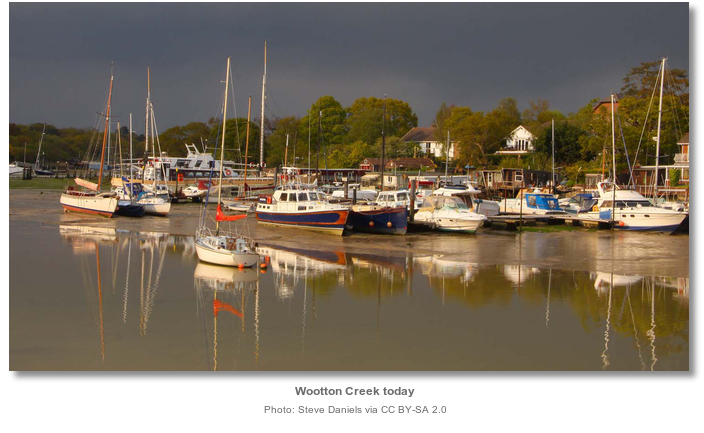
Today Wootton and Fishbourne are predominantly residential villages that reach down to the waterside along the banks of Wootton Creek. Access to the creek is limited due to private land ownership and numerous recreational moorings and pontoons along the creek’s perimeter. The best place to enjoy the creek is The Sloop Inn adjacent to Wootton Bridge at the head of the creek or via a run up to it at high water. The beaches on either side of the creek’s mouth are narrow and discontinuous offering limited if any bathing potential. By far Wootton Creek’s primary attraction is the Royal Victoria Yacht Club pontoon. Their clubhouse and grounds that provide beautiful vistas of the mouth of Wootton Creek are simply wonderful, and their friendly welcome an absolute pleasure.
What facilities are available?
Fresh water is available on the pontoon, and there are showers and toilets in the clubhouse. The club also has a slipway, waste facilities and an excellent bar and restaurant. The Fishbourne Inn, situated close to the ferry, also provides food.The nearest shops are at Wootton Bridge, about half an hour’s walk from the pontoon or a short dinghy ride up the creek on the tide. Those intending to take the dinghy may land at the Council’s public slipway between the Sloop Inn and the bridge on the west bank at the head of the creek. The Sloop Inn has a good value for money restaurant in pleasant surroundings. A post office, Chinese takeaway, Indian takeaway, chip shop, chemist, launderette, doctor and vet, butcher, supermarket, wine warehouse, Tesco Metro (with a cash machine) as well as a garage just outside the village, can be found in Wootton Bridge.
Buses from Wootton Bridge go to Ryde and Newport. The Wightlink Ferries go straight to Portsmouth directly connecting with mainline rail services to London and beyond.
Any security concerns?
Never an issue known to have happened to a vessel along side the Royal Victoria Yacht Club pontoon.With thanks to:
Michael Harpur S/Y Whistler. Photography with thanks to Michael Harpur, Mark Pilbeam, David Dixon, Hugh Venables, Stuart Logan, Lewis Clarke, Steve Daniels, Alex Liivet._isle_of_wight_england_NIC_1111.JPG)
_isle_of_wight_england_geograph_4128638_by_Stuart_Logan.jpg)
_isle_of_wight_england_NIC_1163.JPG)
_isle_of_wight_england_NIC_1055.JPG)
_isle_of_wight_england_NIC_1107.JPG)
_isle_of_wight_england_NIC_1136.JPG)
_isle_of_wight_england_NIC_1189 _ Copy.JPG)
_isle_of_wight_england_NIC_1170.JPG)
_isle_of_wight_england_geograph_1803665_by_Stephen_McKay.jpg)
_isle_of_wight_england_bernard bradley.jpg)
_isle_of_wight_england_NIC_1105.JPG)
_isle_of_wight_england_NIC_1176.JPG)
_isle_of_wight_england_ht Basher Eyre an.jpg)
_isle_of_wight_england_Susan Dixon.jpg)
_isle_of_wight_england_Wootton_Creek_harbour_2.jpg)
_isle_of_wight_england_Wootton_Sloop_Inn.jpg)
_isle_of_wight_england_pyright David Martin.jpg)
_isle_of_wight_england_Susan Dixon a.jpg)
Aerial view of Wootton Creek
Path of the creek as seen early in the morning on a low water Spring Tide


Add your review or comment:
Please log in to leave a review of this haven.
Please note eOceanic makes no guarantee of the validity of this information, we have not visited this haven and do not have first-hand experience to qualify the data. Although the contributors are vetted by peer review as practised authorities, they are in no way, whatsoever, responsible for the accuracy of their contributions. It is essential that you thoroughly check the accuracy and suitability for your vessel of any waypoints offered in any context plus the precision of your GPS. Any data provided on this page is entirely used at your own risk and you must read our legal page if you view data on this site. Free to use sea charts courtesy of Navionics.