
Set almost at the middle of the island and dry for the majority of the time the town offers complete protection from all conditions. Safe access may be had on the top of the tide in all reasonable conditions during daylight.

Keyfacts for Newport
Facilities


Nature


Considerations


Protected sectors

Approaches

Shelter

Last modified
August 24th 2018 Summary* Restrictions apply
A completely protected location with straightforward access.Facilities
Nature
Considerations
HM  +44 1983 525994
  Ch.69
Ch.69
+44 1983 525994 Ch.69 Position and approaches

Expand to new tab or fullscreen
Haven position
 50° 42.282' N, 001° 17.450' W
This is the north end of the drying pontoons.


What are the key points of the approach?
The entry and the run-up thorough The Solent and Southampton Water are covered in
The Solent and Isle of Wight Coastal Overview. The approaches and run up the fairway are detailed in the Folly Inn
  entry.
The Solent and Isle of Wight
Coastal Overview. The approaches and run up the fairway are detailed in the Folly Inn entry.Not what you need?
Click the 'Next' and 'Previous' buttons to progress through neighbouring havens in a coastal 'clockwise' or 'anti-clockwise' sequence. Below are the ten nearest havens to Newport for your convenience.
Ten nearest havens by straight line charted distance and bearing:
- Island Harbour Marine - 1.3 nautical miles NNE
- Folly Inn - 1.8 nautical miles N
- East Cowes Marina - 2.9 nautical miles N
- Shepards Wharf - 3.3 nautical miles N
- Wootton Creek (Fishbourne) - 3.4 nautical miles ENE
- Cowes Yacht Haven - 3.4 nautical miles N
- Osborne Bay - 3.5 nautical miles NNE
- Thorness Bay - 3.6 nautical miles NW
- Cowes Harbour - 3.7 nautical miles N
- Newtown River - 4.6 nautical miles WNW
These havens are ordered by straight line charted distance and bearing, and can be reordered by compass direction or coastal sequence:
- Island Harbour Marine - 1.3 miles NNE
- Folly Inn - 1.8 miles N
- East Cowes Marina - 2.9 miles N
- Shepards Wharf - 3.3 miles N
- Wootton Creek (Fishbourne) - 3.4 miles ENE
- Cowes Yacht Haven - 3.4 miles N
- Osborne Bay - 3.5 miles NNE
- Thorness Bay - 3.6 miles NW
- Cowes Harbour - 3.7 miles N
- Newtown River - 4.6 miles WNW

Chart

How to get in?
Newport is a port and market town, and the capital of the island. It is situated slightly north of centre of the Isle of Wight, four and a half miles upriver and at the navigable limit of the River Medina. The Medina is lit and navigable by boats carrying up to 1.8 metres as far as the Folly Inn. After this it quickly dries and although well marked its buoys are unlit for the last two miles to Newport.
The port is used today by commercial vessels of up to 60 metres. Those prepared to work a favourable tide will find Newport a great lunch stop, or for an overnight stay for those able to dry out.
The town has a maximum draft of 2.5 metres during Springs and 1.7 metres during Neaps. Vessels with a 2 metre draught can reach Newport 1½ hours before HW Portsmouth and 2½ after HW Portsmouth with no trouble and particularly so during Springs. The Solent Spring tides particularly lend themselves to this as Spring high waters always occur around the middle of the day. This tidal window also provides more than 2 metres of water for about four hours on a tide.
However two hours before high water and up to three hours after there is only 1.3 metres of water in Newport. Five hours after high water and the harbour entirely dries to a flat solid mud bottom so it is important to plan correctly. Those in any doubt, or who would like to make advance berthing arrangements, should contact Newport’s Harbour Master on VHF Ch. 69 or P: +44 1983 525994.
 The approaches to Cowes and the run up the River Medina fairway are detailed in the Folly Inn entry.
Just above the Folly Inn the river widens out into Folly Lake, but also shoals with less than a metre available in its deepest parts at low water Springs. Best water can be found by following the lines of mooring piles south of the Folly Inn then steering straight for the green starboard navigational buoy opposite the marina holding pontoon beneath the distinctive hexagonal lock tower of Island Harbour Marina.
Continue past the red port buoy to pass the large hanger on Cement Mills Wharf on the opposite western bank. It has a two pairs of fixed green lights, 2F.G, positioned on either end of its quay. Best water will be found west of centre along this stretch.
Pass under the overhead power cables that span the river a ¼ of a mile above Cement Mills Wharf. It has a safe vertical clearance of 33 metres
Just under 200 metres above the power cables the Medina Valley Centre pontoon will be seen to starboard 2F.G. From this point the rivers large white leading marks on the east bank will come into view. These comprise white diamond top marks, horizontal red lights at night, and when in-line on 192.2°T along with several buoys, they indicate the fairway in the approaches to Newport.
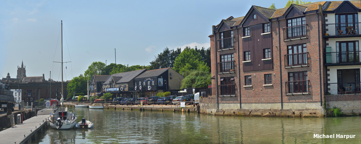
Follow the transit passing The Newport Rowing Club whose clubhouse projects into the river. At the end of this stretch a gentle turn to starboard opens up a view down to Newport’s commercial quays and small craft moorings.
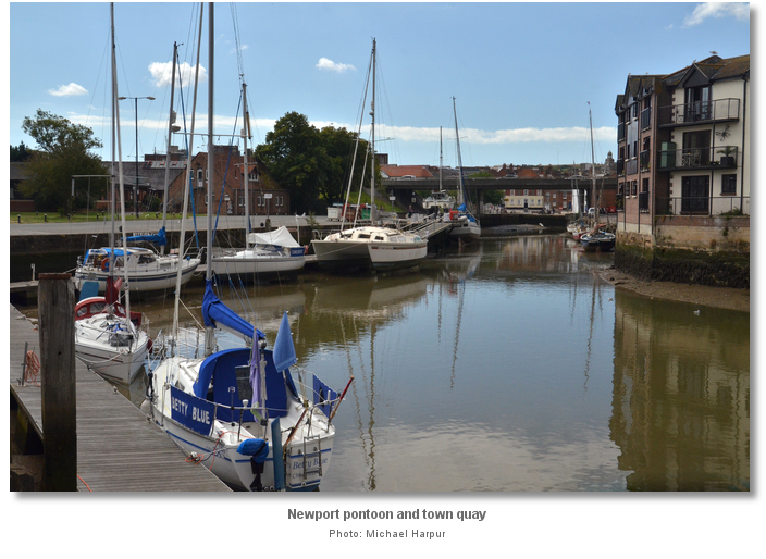
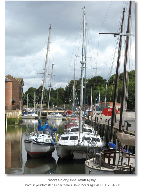
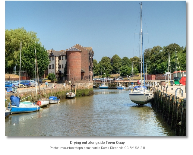
 Bilge keel or multihull vessels that can take to the ground may come alongside the visitors' pontoons. These line Corporation Quay and are encountered on the east side of the river on the final approaches to the town.
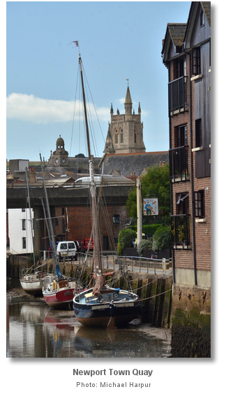
 Single keel yachts should continue upstream and come alongside the Town Quay to the south of the pontoon. The Town Quay has space for about half a dozen yachts to come alongside the wall. The harbourmaster’s office, located on the quay above, can usually provide a visitor with a fender board to help dry out alongside the wall.


Above the quay a dual-carriageway road bridge spans the river creating the navigational limit for sailing vessels. Beyond this the river soon turns into a stream that disappears in to a culvert under an old warehouses, now converted into the Quay Arts Centre.
Why visit here?
Newport is situated slightly north of centre of the Isle of Wight and at the navigable head of the River Medina. It was a planned Norman market town which became the principal one of the island. Its name, originally Neuport, indicated that there was a previous settlement that existed before it was regarded as ‘new’ after being given its 12th Century charter.
The first charter was granted to Newport by Richard de Redvers, Lord of the Isle of Wight, between 1177 and 1184. Newport was one of his three planned towns along with, Yarmouth and Newtown which was then known as Francheville. De Redvers' charter conferred on the town’s inhabitants, their heirs and successors, security of tenure and a release from the slavery of serfdom for which they paid 18 marks yearly. The position of his three planned towns all centred on navigable estuaries and sheltered harbours which focused on their trading capabilities rather than access to good quality agricultural land.

At the time of the Norman Invasion Newport would have been no more than an insignificant village, inhabited by fishermen. But of the three new towns it was made capital because it was the most desirable location on the island. Unlike the other towns it was surrounded by good land, was well watered by the Medina and provided moored vessels with excellent shelter. Being central it was convenient for land communications to every other part of the isle. The river also worked tide mills to grind the corn, which enabled it to be traded by the sea beyond and conveyed tradeable commodities back in return. A considerable trade was carried on in timber, malt, wheat and flour, and it quickly developed. The charter, superior river position for trade, harbour dues and the oyster beds of the Medina caused Newport to rise in importance.
But the 14th century was to bring a setback to the town in the form of pestilence and war. In 1349 the Black Death came to Hampshire and the Isle of Wight. One third of the population were believed to have died but coastal areas took the brunt of the suffering with losses of more than 50% in many cases. In August 1377, whilst the town was still on its knees, it was raided by the French. They burnt much of Newport to the ground whilst attempting to take Carisbrooke Castle. By recompense little quarter was given to captured French invaders. They were killed and buried in a large pile of earth, or tumulus, that was later nicknamed ‘Noddies Hill’ where the word ‘noddy was used as a casual medieval word for a corpse. This name softened through the centuries to ‘Nodehill’ which today is at the centre of Newport. To the casual observer, unaware of its origin, the name would appear at odds with the flat area it describes today.
The town grants were nevertheless repeated and extended by the countess Isabel de Fortibus, which were confirmed in 1349 by Edward III and afterwards by successive kings. Henry VII, in 1489, granted in addition the petty customs within all ports and creeks of the island. The borough was incorporated by James I in 1607, and a second charter of incorporation granted by Charles I in 1637 is that by which Newport was governed until 1835. Little did Charles I know in 1637 how much a decade later that Newport and Carisbrooke were to feature in the last days of his life.
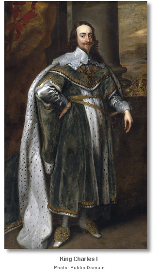
In a secret treaty, called the ‘Engagement’, he secured their commitment to invade England in support of a rising to restore him to the throne. The royalists rose in May 1648, igniting the Second Civil War, and as agreed with Charles, the Scots invaded England. The New Model Army deftly put down the rising in England and defeated the Scots at the ‘Battle of Preston’ in August 1648. After this the army finally consolidated its control over England eliminating any chance the Royalists had of winning the war.
With no other recourse Charles was forced to negotiate the ‘Treaty of Newport’ with a group of Parliamentary Commissioners. This was aimed at bringing to an end the hostilities of the English Civil War. Released on parole from confinement at Carisbrooke Castle, of which he made two ineffectual attempts to escape, negotiations took place in Newport where he lodged during these talks. Much hollow diplomacy ensued and although the treaty was signed by Charles he showed no commitment to any compromised settlement and patience was running thin with Cromwell and the army. They viewed him as a bloody tyrant who had already taken action to consolidate his power. In what amounted to a coup they finally put an end to it and seized the King in Newport. They then transferred him to Hurst Castle, on the mainland, before bringing him to London. The Treaty of Newport was purged in December 1648 and preparations for the King's trial went ahead. Charles was convicted with high treason and on January 30th 1649, before the executioner’s axe fell, he observed ‘how short is the step between the prisons and the graves of princes. ’.

Newport today is the shopping centre of the Isle of Wight and principal administrative centre. Though Ryde is the island's largest town with a population of around 30,000 to Newport’s 25,000, Newport is still considered by most to be the Island’s capital. Newport has undergone various changes in recent times with two shopping centres and many recent development efforts. This includes Newport Quay that has new art galleries such as the Quay Arts Centre, and new flats converted from old warehouses. Nelson Road is the chief centre of the islands bus system from where a bus can be caught to almost anywhere on Island.

Dotted around the town there are a host of places of historical interest. This historic town centres on two elegant squares which are surrounded by Georgian and Victorian architecture, with the town’s quay a short distance away. The magnificent church of St. Thomas of Canterbury, rebuilt in 1854, contains many interesting old monuments including one by Marochetti to the princess Elizabeth, daughter of Charles I, erected by Queen Victoria. The beautiful guildhall, erected in 1816 from the designs of Nash, includes the town hall. Beneath it there is a regular market which is based across the town on a Tuesday, with a highly rated farmers market selling a good range of local produce on Fridays. The Museum of Island History, Classic Boat Museum and the Newport Roman Villa are all within walking distance of the town centre. One of the oldest surviving buildings in Newport is the Grammar School that dates back to 1612. It was here that Charles I lodged for 10 weeks while the Treaty of Newport was being negotiated. The historic motte-and-bailey Carisbrooke Castle and the rooms in which Charles was imprisoned is a 30 minute walk away.

From a sailing point of view Newport harbour feels like a step back in time that is a complete contrast to Cowes, especially so during Cowes Week. Offering perfect shelter it makes for an ideal harbour in bad weather. All the facilities of the town including shops, restaurants and multi-screen cinema are a short stride from its quay, provisioning is excellent and there is plenty of historical interest to explore around this beautiful medieval market town. Likewise being at the heart of the island with the bus service’s arterial routes running through, it makes an ideal base from which to explore the island’s many attractions via road.
What facilities are available?
The visitors drying pontoons are fully serviced with water and power. Ablution and laundry facilities are available above on the quayside. The harbourmaster's office provides fender boards for vessels intending on drying out alongside Town Quay. Four slipways can be found around the harbour along with a hand-operated crane.Countless boatyards along the river Medina can solve any boating problem. Cowes as a whole offers almost any conceivable marine service or facility a vessel could require. Petrol and diesel on the river approaches are available from Lallow's Boatyard, between Cowes Yacht Haven and Shepards Wharf or more conveniently from Cowes Harbour Fuels barge close south of the chain ferry, +44 1983 200716. Cowes Harbour Fuels also supply Calor gas. Newport Town Quay provides excellent scrubbing berths at low water.
Newport, the County Town of the Island, has an abundance of pubs, shops and restaurants. It has all the essentials such as the post office and pharmacists on the High Street, and supermarkets such as Sainsbury's, Somerfield and Marks & Spencer spread out around the town. Likewise all the major banks can be found along the High Street, most with cash machines. The town hosts a market on Tuesdays and a Farmers' market on Fridays.
With thanks to:
Michael Harpur S/Y Whistler. Photography Michael Harpur, Ronald Saunders .


The following video presents an overview of Carisbrooke Castle.


Add your review or comment:
Please log in to leave a review of this haven.
Please note eOceanic makes no guarantee of the validity of this information, we have not visited this haven and do not have first-hand experience to qualify the data. Although the contributors are vetted by peer review as practised authorities, they are in no way, whatsoever, responsible for the accuracy of their contributions. It is essential that you thoroughly check the accuracy and suitability for your vessel of any waypoints offered in any context plus the precision of your GPS. Any data provided on this page is entirely used at your own risk and you must read our legal page if you view data on this site. Free to use sea charts courtesy of Navionics.