

Folly Reach is located off the south coast of England within The Solent, and at the heart of the Isle Of Wight. It offers a mid-river pontoon, with the possibility of a walk-ashore berth, in a particularly attractive location with an excellent pub.
Set more than two miles from the river's entrance and in the centre of the Isle of Wight the Folly Inn offers complete protection. Access is straightforward in all reasonable conditions day or night and for moderate draft vessels at all stages of the tide.


Keyfacts for Folly Inn


Summary
A completely protected location with safe access.


Nature


Considerations


 +44 7884 4000 46
 follymoorings@hotmail.com
 Ch.72 [Folly Launch]
Position and approaches

Haven position
 50° 44.010' N, 001° 16.917' W
This is the position of the Folly Inn shore pontoon.
What is the initial fix?
 50° 46.110' N, 001° 18.035' W


What are the key points of the approach?
The Solent and Isle of Wight
 Coastal Overview.
 - Keeping 200 metres offshore on approaches from the west and east avoids all local dangers. Maintain a careful watch for unlit moorings at night.
- Vessels approaching from the north must abide by the special rules of the Southampton Precautionary Area or ‘Area of Concern’.
- Within the entrance follow the series of landings, marina pontoons and piers with deep water close alongside up river to the chain ferry that has absolute right of way.
- Continue upriver past the National Power Jetty where the channel starts to narrow and shallow.
- Berth alongside the pontoon on the west side of the river or alongside the walk ashore pontoon in front of the Folly Inn.
Not what you need?
- Island Harbour Marine - 0.5 nautical miles S
- East Cowes Marina - 1.2 nautical miles NNW
- Shepards Wharf - 1.6 nautical miles NNW
- Newport - 1.8 nautical miles S
- Cowes Yacht Haven - 1.8 nautical miles NNW
- Osborne Bay - 1.8 nautical miles NE
- Cowes Harbour - 2.1 nautical miles NNW
- Wootton Creek (Fishbourne) - 2.6 nautical miles E
- Thorness Bay - 3.1 nautical miles W
- Ryde Roads - 3.7 nautical miles E
- Island Harbour Marine - 0.5 miles S
- East Cowes Marina - 1.2 miles NNW
- Shepards Wharf - 1.6 miles NNW
- Newport - 1.8 miles S
- Cowes Yacht Haven - 1.8 miles NNW
- Osborne Bay - 1.8 miles NE
- Cowes Harbour - 2.1 miles NNW
- Wootton Creek (Fishbourne) - 2.6 miles E
- Thorness Bay - 3.1 miles W
- Ryde Roads - 3.7 miles E


How to get in?

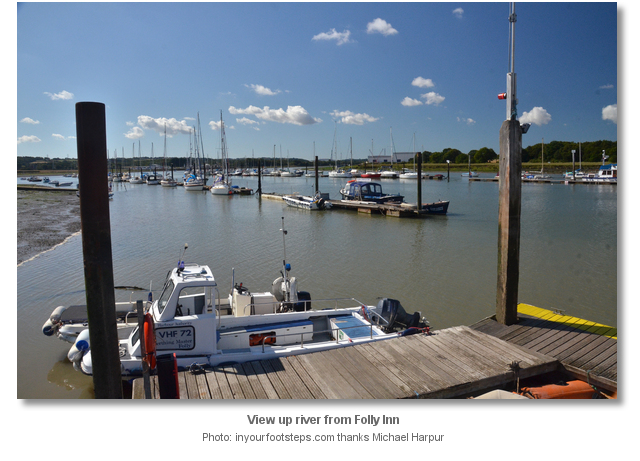
The Folly Reach moorings are situated on the River Medina 2½ miles upriver from the entrance to Cowes. Its berths are predominantly alongside a mid-river pontoon, situated on the west side of the river, but there are some walk ashore berths alongside the jetty that fronts the Folly Inn. Folly Reach offers a very good berth alongside an excellent Inn in a quiet stretch of the river where the Medina’s beauty may be enjoyed.
At high water, the River Medina is navigable all the way to Newport but Folly Reach is freely accessible by the vast majority of vessels at all states of the tide. Boats with deeper drafts may require some planning and particularly so on Springs. The river has 2 metres LWS up to Medham where the port hand red No. 8 Fl.R.2s is situated. About 300 metres to the south of this mark depths start to drop to about 1 metre LWS to the Folly Inn Pontoon. Vessels carrying 1.8 metres have enough water an hour and a half either side of LWS.
Since the construction of a new 350 metre breakwater, protecting Cowes’ outer harbour from northerly winds, the river is subject to silting, and depths may reduce. Nevertheless, those who are pushing the margins will find the river highly protected and its bed entirely made up of soft silt. If a vessel was to run aground for a short period the vessel is in no danger awaiting a rise. The Folly Launch is more than happy to run downriver to take off the crew members who would prefer to wait for the rise in the Folly Inn.
Berths are usually available, but it is possible to guarantee a berth by e-mailing follymoorings@hotmail.com and making arrangements in advance. It is particularly advisable to make advance arrangments during Cowes Week and the Round Island Race when berths are highly saught after. In all cases it is best to contact the Folly Inn Berthing Masters VHF Ch. 72 P: +44 7884 4000 46 at the port hand red No. 8 East Medham buoy. They are happy to assist, and the notice helps them to optimise their berthing arrangements. As a rule, they could not be more helpful and are only too delighted to support the berthing of boats including taking lines or providing a vessel with a helpful nudge in.
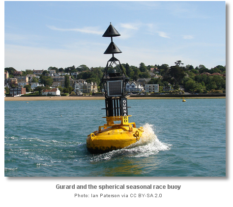
 Few hazards are encountered by vessels approaching from the west. Egypt Point, made conspicuous by a prominent beacon column standing 7 metres high has a race mark and the Gurnard north cardinal mark which stands 400 metres north of the beacon. The point should be given a wide berth as it is foul out to 150 metres. Keeping inside the Gurnard north cardinal buoy and outside the race mark avoids entering the Southampton Precautionary Area or ‘Area of Concern’ detailed below.
 Between Egypt Point and the entrance vessels should stand 200 metres off the shoreline, or outside the 5 metres contour, to avoid the drying Grantham Rocks. An easier mark by day to avoid these dangers is to keep north of the line of moorings laid east of Gurnard North Cardinal and 100 metres north of the rocks. At night the same moorings are unlit and a close lookout is required to avoid them.
On the final approaches to the harbour, vessels should avoid coming inshore under the Royal Yacht Squadron building as there is a reef located 100 metres northwest of the foot of the building sometimes known as Lion Rock.

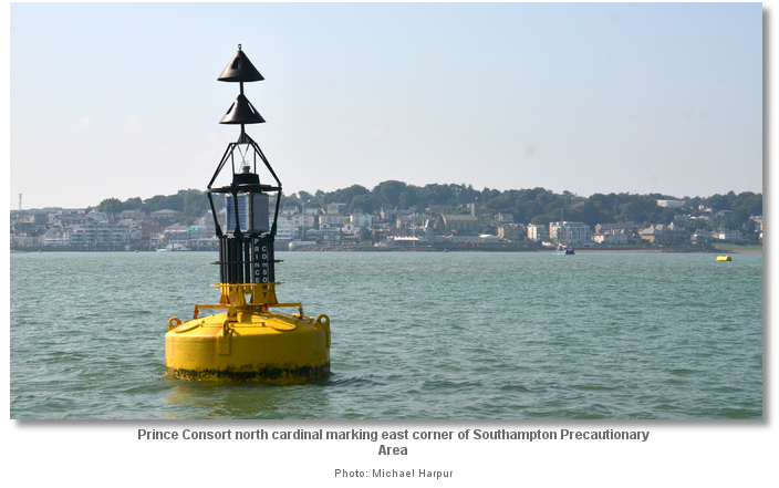
 Vessels approaching from the north must abide by the special rules to assist the movements of shipping in the road up to the entrance to Southampton Water known as the Southampton Precautionary Area or ‘Area of Concern’. This restricted entry area lies outside the River Medina entrance, east of the line between the Gurnard and west of the Prince Consort North Cardinal Buoy. From this southern limit, as best seen on a chart, the restricted area follows the deep water channels around the Bramble Bank to the Horn starboard buoy within the entrance to Southampton Water.
 In this body of water, large vessels of over 150 metres length overall when entering the ‘Area of Concern’, has a ‘Moving Prohibited Zone’ of 1,000 metres ahead and 100 metres to either side. A craft under 20 metres (66ft) ‘Length Overall’ are prohibited from entering this ‘Moving Prohibited Zone’. Whenever possible, vessels over 150 metres are escorted by a patrol launch showing a blue flashing light. The absence of the launch does not invalidate the ‘Moving Prohibited Zone’.
It is essential to obey ‘Area of Concern’ distancing rules. Craft in breach or these rules will not only be subject to hefty fines but are putting the safety of the vessel and all aboard in jeopardy. If there is any doubt or concern the Harbour Patrol Launch, call sign [Southampton Patrol], maintains a listening watch on VHF Channel 12. The crew are happy to offer advice and information on the harbour and approaches.
Navigators should also note the position of the well-known and well-marked Bramble Bank specifically catered for large ships in the special arrangements of the ‘Area Of Concern’. The bank dries to 1.2 metres and it is all too often overlooked by leisure vessels making their way to Cowes.
 Vessels approaching from the east should stand well off Old Castle Point and use the yellow race mark, moored in about 4 metres of water, as a good mark for offing. Upon rounding this mark an eastern approaching vessel, or a northern approaching vessel, may use the Small Craft Channel as a convenient cut into the main Cowes Harbour fairway.
 The Small Craft Channel passes north of The Sharpe Mud and Sharpe Breakwater into the harbour. It has a minimum depth of 0.2 metres below chart datum and, being only 35 metres wide at its narrowest point; it is also narrow. However it is well marked with tidal gauges on either end, three pairs of lit lateral buoys, progressing inward Fl.R.2s / Fl.G.2s, Fl.R. 5s / Fl.G.5s, then off the head of the Sharpe Breakwater, Fl.R.3s / Fl.G.3s leading to three lit Yellow markers and the 4A Red Beacon, L Fl.R.5s, at its western end where it joins the Inner Fairway near the Red Jet terminal. Cowes Harbour Commission actively encourage leisure craft to use the eastern Small Craft Channel, but it is in no way mandatory.

Those choosing to use the Small Craft Channel should find the Shrape Beacon, LFl.R.10s 3m 3M, situated about 300 metres northwest of Old Castle Point and 200 metres eastward of the channels outer entrance. The Shrape Beacon, as with its corresponding inner 4A Beacon inside the main fairway, has a tidal gauge indicating the available depth over Chart Datum. All that is required is to add 20 cm to the height indicated on the gauge, and it is very quick and easy to determine if the height of tide encountered is adequate to use the cut. When approaching the Shrape Beacon vessels should keep clear of the moorings either side or the Shrape Watersports Area located to the east of the Shrape Breakwater as races are often held in this area. Within the Small Craft Channel, the helmsmen should prepare for strong cross currents that can attain rates of up to 2.5 knots during spring ebb tides. Finally, take care not to impede commercial vessels in the Inner Fairway when exiting the channel’s western end.
 When converging upon the river entrance be sure to make 360° sweep for shipping movements. The High-Speed Catamaran service has its berth on Cowes Town Quay and the larger Ro-Ro ferries at East Cowes. Several commercial ships also visit the many wharfs and quays of the River Median. Leisure yachts converge to start or finish a race in front of the Royal Yacht Squadron clubhouse or the harbour entrance.
A watchful eye for tidal flows is essential in the Outer and Inner Fairway. Between HW -3 and HW a strong westerly setting current, that attains speeds of up to 4 knots can be experienced across the entrance.
The new 350 metre breakwater in Cowes outer harbour is now in place and has altered tidal streams in the harbour and particularly so the westerly setting cross current that has been divided by the structure. It now pushes strong currents north and further south inside the outer harbour while creating a tidal shadow of slack water immediately to the southwest of the breakwater. From HW -3 to HW expect the current to be set towards the western shore in the Inner Fairway.
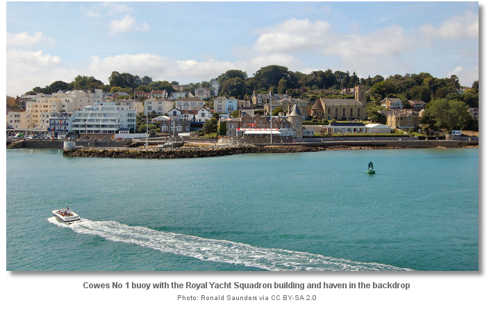
 From the initial fix the Starboard hand green No. 1 and port hand red No. 2, situated 200 metres to the east, are readily apprarent. Likewise Cowes behind, situated on both sides of the entrance divided by the river into its two parts of Cowes and East Cowes. From here it is a simple matter of passing through the marks and entering the Inner Fairway at the mouth of River Medina to the north of the Royal Yacht Squadron building and haven.
 Take care when approaching the new breakwater as there is an exclusion zone around it. The breakwater and exclusion zone buoys are lit at night which can be confusing when arriving at Cowes in the dark.
Once within the entrance, there is a speed limit of six-knots, and it is advisable for sailing vessels to operate under power, especially so in the vicinity of the chain ferry. The inner harbour is very well marked and lit at night with two port hand buoys No. 4 Fl 3R5s and No. 6 Fl 2 R5s. The starboard side has a series of landings, marina pontoons and piers with deep water close alongside. At night everything is lit 2FG (vert) or 2FR (vert).
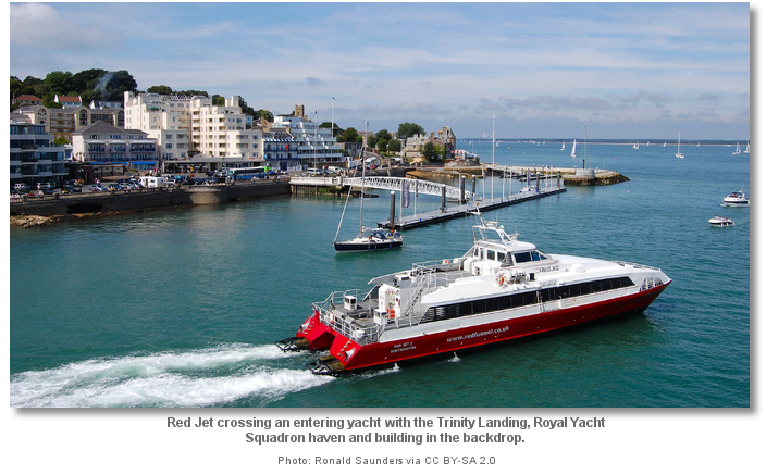
Follow the main channel keeping close to Cowes’ western shoreline passing at first the Royal Yacht Squadron's yacht haven. This haven is only available to Royal Yacht Squadron members but Cowes Harbour Commission’s Trinity Landing, located immediately south, is available to make a quick set-down or collection and has the possibility of an overnight stay.
Cowes Harbour's ‘M row’ and ‘J row’ of swinging moorings, laid outside the harbour, Trinity Landing, Town Quay, Shepards Wharf and Whitegates River Pontoons, located on the eastern side of the fairway immediately south of the Chain Ferry, are all managed by Cowes Harbour Commission and covered in the Cowes Harbour
 entry. Contact the Harbour Master on Ch. 69 to make use of any of these berthing options.
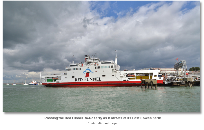
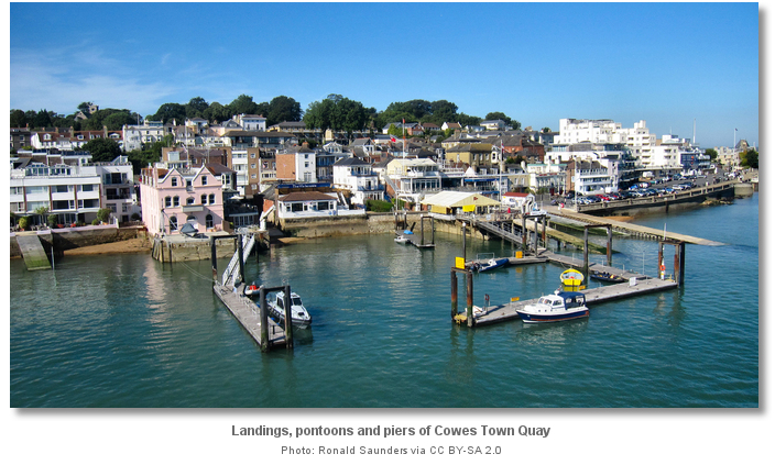
400 metres up-river on the starboard-hand side are the jetties and pontoons of the Town Quay. The Town Quay is normally overwhelmed by small boats and RIBS, to which it is best suited, and there may be some small boat activity exiting or entering this area.
The Red Jet High-Speed catamaran passenger ferry berth is on the Jubilee Pontoon that stands out from the Town Quay. A keen eye should be maintained for any movement of this vessel as it typically crosses the path of a yacht entering the harbour. Approaching its berth, the Hi-Speed Catamaran ferry turns round, to starboard, in a tight circle to face outward.

The larger Red Funnel Ro-Ro car ferry berths 600 metres above on the opposite East Cowes side of the river. There is ample room for it to pass along the eastern shore but it may use thrust when manoeuvring causing unexpected turbulence in the river.

Immediately upriver of the Jubilee Pontoon on the wester shore is Cowes Yacht Haven
marina. Cowes Yacht Haven is the first of the Cowes’ marinas and, as it fronts the town, it is extremely popular. Immediately upriver from Cowes Yacht Haven, only separated by a fuel jetty, is the second and smaller of the town's marinas Shepards Wharf that is likewise only a couple of minutes from the town centre. Both marinas make the vast majority of their berths available for visitors. 
150 metres south of Shepards Wharf Cowes Chain Ferry plies its trade, 18 hours a day 365 days a year, across the narrow mouth of the River Medina between Cowes and East Cowes. Be prepared to stop and turn immediately if the white light at the front of the vessels pilot house starts to flash as the chain ferry asserts its right of way. When the ferry is alongside a minimum depth of 1.7 metres below chart datum can be expected above the chains in the centre of the fairway.

100 metres above the chain ferry, on the west or starboard side, is the river's most convenient fuel jetty. On the opposite port side and eastern bank are Cowes Harbour Commission's Whitegates River Pontoons. Immediately above this is East Cowes Marina
. Upriver of the chain ferry, the channel is flanked by port and starboard jetties and pontoons. All are well lit with 2FR (vert) and 2FG (vert) as far as the conspicuous National Power Jetty. After this, the east side of the river is marked by two lit port hand red buoys, No. 8 and No. 10, and lines of private pontoons that flank the west side of the river of which most are lit at their end-posts.

400 metres above the National Power Jetty the channel starts to narrow and abruptly shallow. Between the Medham beacon, VQ3 5s, and The Folly Inn the depth is at times only about 1 metre LWS. From this point on, the best water is found 20 metres out from the side of the river pontoons on the starboard side.
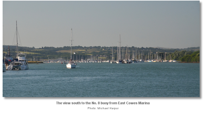
The Folly Inn, on the east side of the river, makes itself plain by the word ‘INN’ clearly marked in white on its black slate roof. On closer approaches, the transition from private moorings to the commencement of the Folly Inn Visitor pontoons are clearly marked by signs on the northern end posts.
 The visitors' pontoons are situated on the floating pontoon on the west side of the river. Land at the Folly Inn jetty by tender or make use of the Folly Launch. Berthing fees (2016) 1.45 per metre.
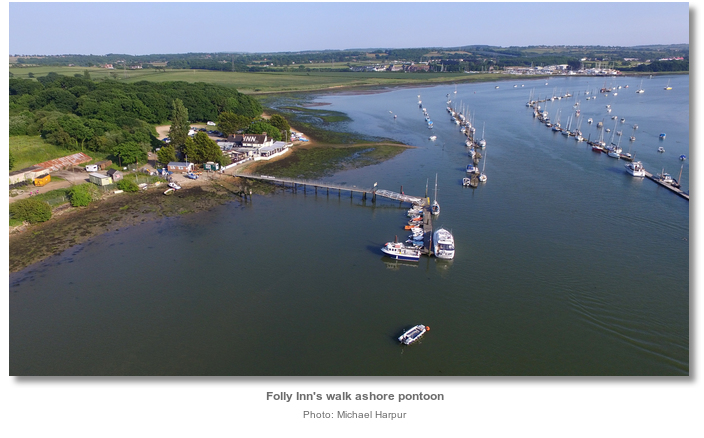
There are a handful of berths available on the pontoon outside the Folly Inn. These provide power, water and walk-ashore access but these require special arrangements with the Folly Inn. The Folly Waterbus runs a service to Cowes (30 minutes, circa £10 return per person) throughout the year. Call Dave Ch. 77 or + 44 7974 864 627.

Just above the Folly Inn, the river widens out into Folly Lake that dries less that ½ mile to the south. Island Harbour Marine
, located about ½ mile above Folly Inn, is accessible on a favourable tide. Vessels with a 2 metre draught can carry on upriver and reach the Island capital of Newport 1½ hours before HW Portsmouth and 2½ after HW Portsmouth.Why visit here?
The River Medina derives its name from the Old English word ‘Meðune’ meaning ‘the middle one’. The name was most likely chosen for being the middle of the island’s three main rivers, and for almost dividing the island in two from south to north across its middle. Its current ‘Medina’ pronunciation was first recorded in 1196.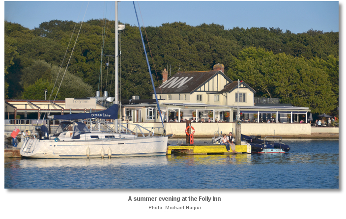
All the island’s main rivers flow northwards and are, or have been, tidal estuaries for part of their length. The island's other rivers are the Yar to the east, that enters into the sea near Bembridge, and which is sometimes known as the ‘East Yar’ to differentiate it from the other main river Yar, sometimes known as the ‘West Yar’, that enters the sea at Yarmouth and is estuarine for most of its short length. The Medina is by far the largest of the three and was once a tributary of the ‘River Solent’ when it would have had a much larger catchment area. At the end of the ice age The Solent valley flooded, the island eroded, the Medina received less water flow and more sediment causing it to become largely tidal. It is bridged today at Newport, the island capital, where it is emerges as a stream descending from the chalk springs of St. Catherine’s Down on the south side of the Island. The river is navigable northwards from Newport on the tide after which it takes the form of a drowned valley or Ria.
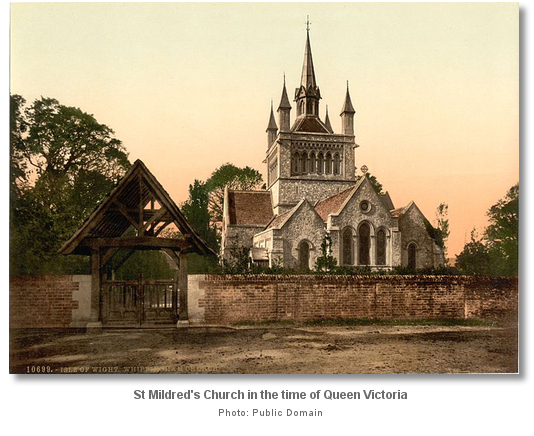
A twenty minute stroll inland from the Inn, through attractive ascending pastoral fields, brings a visitor to Whippingham’s beautiful St. Mildred's Church that can be seen above the tree line from the moorings. Being dedicated to the Anglo-Saxon princess St. Mildred, who died about 700 AD, the church has deep Anglo-Saxon roots. It was rebuilt by the Normans who recorded it in the Doomsday book of 1086 and it retained its Norman design until the beginning of the 19th century. Then the renowned architect John Nash, the favourite architect of George IV., almost entirely levelled the original structure and rebuilt it to his own design. In 1845 Queen Victoria and Prince Albert bought Osborne House and Whippingham, the centre of the estate supporting Osborne House, Barton Manor, and its little village church, which became a centre of royal interest.

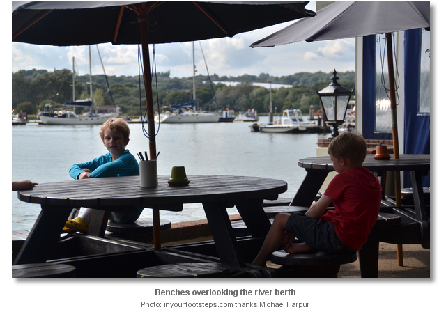
Folly Reach provides a wonderful Medina berth where its quiet reaches can be fully enjoyed. If the weather is fine it is worth turning the boat to face north to fill the cockpit with sunshine throughout the day. Ashore the Folly Inn has to be close to the perfect riverside pub with its good food and friendly nature making it a fond favourite with sailors.

There is little else ashore apart from the inn and the picture perfect church, but Newport is accessible by dinghy on the rise and by bus from the top of the road leading down to the inn. There is also a wonderful riverside pathway, or country walk, to the island’s capital along the bank of the river.
One of the Follie’s easily overlooked assets is the water taxi service operated by the berthing masters. Situated midway along the four-mile run between Cowes and Newport, the latter half being tidal, the water taxies provide an on-demand, fast and efficient service between to the towns. This capability is well worth noting during ‘Cowes Week’ and the ‘Round Island Race’ when Cowes can become overwhelmed with visiting boats and its prices elevate. A Folly berth may always be guaranteed by e-mailing in advance, and although it cannot guarantee an unbooked berth during these two major events, it has never failed to accommodate any vessel that has randomly turned up in the past 15 years.

The advantages of the Folly is that they do not raise their fees during these events making their berths a diminutive fraction of the Cowes’ cost. Add the water taxi service to this and there is little disadvantage to berthing here. Celebrators can be swiftly dropped into the heart of the action in Cowes and collected into the early hours for what would be a fraction of the saving in berthing fees. It is also worth noting that the water taxi service to Cowes may be used free of charge during the ‘Round the Island Race’. From 3 pm to midnight, on the day before the race, and 3 pm to 1 am on the day of the race the taxi service is typically sponsored by JP Morgan. The taxi service also greatly facilitates provisioning runs to Cowes or Newport along with crew changes directly to the Cowes ferry jetties. The taxi service truly makes the Folly a viable alternative to a berth in the heart of very busy Cowes.

From a sailing perspective, the Folly has to rank as one of the most easily addressed, pleasant and effective berths available to a cruiser on the Isle of Wight.
What facilities are available?
The mid-river pontoon has no water nor electricity but the walk ashore jetty in front of the Inn has power and water. It is possible to come in temporarily to fill the water tanks. The Folly has a scrubbing berth for vessels up to 10.5 metres LOA and 1.80m draft on spring tides. Apply to Medina Mariners Association P: +44 1983 866667. Alternatively low water at Newport, 2 miles above, presents an ideal opportunity to scrub off. Coin operated showers can be found to the rear of the Folly Inn. The Inn serves good food and has entertainments, most notably its lively table dancing, on Saturday nights. Apart from that there is little in the area.Cowes, passed on entry, caters for all marine services and facilities a vessel could require. Petrol and diesel are available from Lallow's Boatyard, between Cowes Yacht Haven and Shepards Wharf or more conveniently at Cowes Harbour Fuels, +44 1983 200716, south of the chain ferry. Cowes Harbour Fuels also supply Calor gas. Water can be obtained at Trinity Landing, Town Quay, Whitegates walk ashore pontoon and Thetis pontoon as well as the Folly Jetty. The Town Quay has scrubbing berths next to the Harbour Office as does the Folly Inn for smaller boats.
The water taxi service (2016) charges £10 return to Cowes or Newport per adult and £7 one way. Island Harbour marina is £3 or a short stroll. Newport can be reached by dinghy on the rise or by bus from a stop located about 10 minutes’ walk from the Inn. It has excellent provisioning capability. Likewise Cowes has excellent provisioning and it may be reached by water taxi at any time.
Any security concerns?
Never an issue known to have occurred to a vessel moored in Folly Reach.With thanks to:
Dave Foyle, Bob Holt, Phil Glover and Matty Jones Folly Berthing Master. Photography Michael Harpur, Steve Fareham, David Dixon, Peter Trimming and an especial thank you to Ronald Saunders.


This video presents an aerial overview of Cowes and the entrance to the River Medina.
This video presents an aerial overview of The Folly Inn and the mooring in the River Medina.
This East Cowes Marina video presents the run up the river, in a RIB, from Prince Consort North Cardinal to East Cowes Marina.
About Folly Inn
The River Medina derives its name from the Old English word ‘Meðune’ meaning ‘the middle one’. The name was most likely chosen for being the middle of the island’s three main rivers, and for almost dividing the island in two from south to north across its middle. Its current ‘Medina’ pronunciation was first recorded in 1196.
All the island’s main rivers flow northwards and are, or have been, tidal estuaries for part of their length. The island's other rivers are the Yar to the east, that enters into the sea near Bembridge, and which is sometimes known as the ‘East Yar’ to differentiate it from the other main river Yar, sometimes known as the ‘West Yar’, that enters the sea at Yarmouth and is estuarine for most of its short length. The Medina is by far the largest of the three and was once a tributary of the ‘River Solent’ when it would have had a much larger catchment area. At the end of the ice age The Solent valley flooded, the island eroded, the Medina received less water flow and more sediment causing it to become largely tidal. It is bridged today at Newport, the island capital, where it is emerges as a stream descending from the chalk springs of St. Catherine’s Down on the south side of the Island. The river is navigable northwards from Newport on the tide after which it takes the form of a drowned valley or Ria.
A twenty minute stroll inland from the Inn, through attractive ascending pastoral fields, brings a visitor to Whippingham’s beautiful St. Mildred's Church that can be seen above the tree line from the moorings. Being dedicated to the Anglo-Saxon princess St. Mildred, who died about 700 AD, the church has deep Anglo-Saxon roots. It was rebuilt by the Normans who recorded it in the Doomsday book of 1086 and it retained its Norman design until the beginning of the 19th century. Then the renowned architect John Nash, the favourite architect of George IV., almost entirely levelled the original structure and rebuilt it to his own design. In 1845 Queen Victoria and Prince Albert bought Osborne House and Whippingham, the centre of the estate supporting Osborne House, Barton Manor, and its little village church, which became a centre of royal interest.
Folly Reach provides a wonderful Medina berth where its quiet reaches can be fully enjoyed. If the weather is fine it is worth turning the boat to face north to fill the cockpit with sunshine throughout the day. Ashore the Folly Inn has to be close to the perfect riverside pub with its good food and friendly nature making it a fond favourite with sailors.
There is little else ashore apart from the inn and the picture perfect church, but Newport is accessible by dinghy on the rise and by bus from the top of the road leading down to the inn. There is also a wonderful riverside pathway, or country walk, to the island’s capital along the bank of the river.
One of the Follie’s easily overlooked assets is the water taxi service operated by the berthing masters. Situated midway along the four-mile run between Cowes and Newport, the latter half being tidal, the water taxies provide an on-demand, fast and efficient service between to the towns. This capability is well worth noting during ‘Cowes Week’ and the ‘Round Island Race’ when Cowes can become overwhelmed with visiting boats and its prices elevate. A Folly berth may always be guaranteed by e-mailing in advance, and although it cannot guarantee an unbooked berth during these two major events, it has never failed to accommodate any vessel that has randomly turned up in the past 15 years.
The advantages of the Folly is that they do not raise their fees during these events making their berths a diminutive fraction of the Cowes’ cost. Add the water taxi service to this and there is little disadvantage to berthing here. Celebrators can be swiftly dropped into the heart of the action in Cowes and collected into the early hours for what would be a fraction of the saving in berthing fees. It is also worth noting that the water taxi service to Cowes may be used free of charge during the ‘Round the Island Race’. From 3 pm to midnight, on the day before the race, and 3 pm to 1 am on the day of the race the taxi service is typically sponsored by JP Morgan. The taxi service also greatly facilitates provisioning runs to Cowes or Newport along with crew changes directly to the Cowes ferry jetties. The taxi service truly makes the Folly a viable alternative to a berth in the heart of very busy Cowes.
From a sailing perspective, the Folly has to rank as one of the most easily addressed, pleasant and effective berths available to a cruiser on the Isle of Wight.
Other options in this area
Osborne Bay - 1.1 miles NE
Wootton Creek (Fishbourne) - 1.6 miles E
Ryde Roads - 2.3 miles E
Ryde Harbour - 3 miles E
Newport - 1.1 miles S
Shepards Wharf - 1 miles NNW
Cowes Yacht Haven - 1.1 miles NNW
Cowes Harbour - 1.3 miles NNW
Navigational pictures
These additional images feature in the 'How to get in' section of our detailed view for Folly Inn.


| Detail view | Off |
| Picture view | On |
This video presents an aerial overview of Cowes and the entrance to the River Medina.
This video presents an aerial overview of The Folly Inn and the mooring in the River Medina.
This East Cowes Marina video presents the run up the river, in a RIB, from Prince Consort North Cardinal to East Cowes Marina.
Add your review or comment:
Unknown wrote this review on Jun 7th 2016:
The Folly Inn is a wonderful haven that I dearly love. To me it has everything but I want to use the comment section to mention how helpful and friendly the people who man the berthing master / boat taxi service are here. A great example was when I arrived ashore with a wedged canoe oar. The kids somehow manged to ram the two long ends of a pair of canoe oars together, ….add a little sand plus a little corrosion, and they were never ever coming apart again. I had been carrying the ungainly 2.5 metres over-side creation along the deck for a week. I had finally built up the significance annoyance required to give in to the inevitable hacksaw moment. So I came up the jetty. The berthing master ‘Graham’ saw the oversized edifice and no explanation was required. He said he could fix it ‘no trouble’ … I doubted it, but in like Flynn he was bringing heat, lubrication oil and all sorts of potions ....not a budge (and in my opinion ‘a hope’). The kids were edging to get going so I headed off. Sure enough I came back and found two long ends of canoe oars in my dinghy waiting for me. Could I give some money, not a hope, buy him a drink …no Graham was a teetotaller (yea right I discovered later) and so on. All he said was thanks will do delighted to help. So Graham, Thanks! You are a star. In fact all of the Folly berthing masters are.
Average Rating:
Please log in to leave a review of this haven.
Please note eOceanic makes no guarantee of the validity of this information, we have not visited this haven and do not have first-hand experience to qualify the data. Although the contributors are vetted by peer review as practised authorities, they are in no way, whatsoever, responsible for the accuracy of their contributions. It is essential that you thoroughly check the accuracy and suitability for your vessel of any waypoints offered in any context plus the precision of your GPS. Any data provided on this page is entirely used at your own risk and you must read our legal page if you view data on this site. Free to use sea charts courtesy of Navionics.