

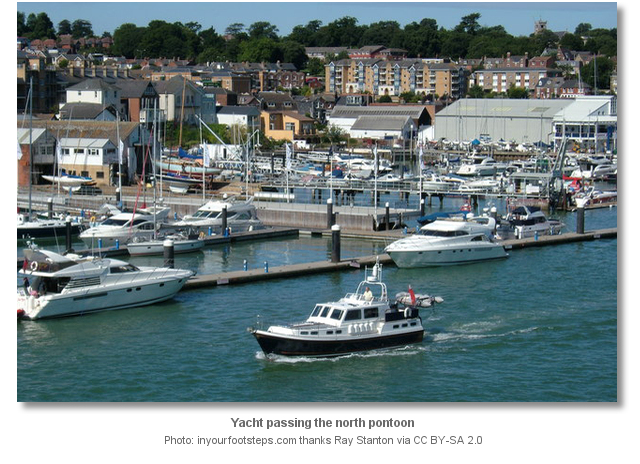
Shepards Wharf is located off the south coast of England within The Solent and in the centre of the Isle of Wight’s principal port of Cowes. It is a medium sized marina with the vast majority of its berths made available to cater for the thousands of visitors that come to the town which is the centre of UK sailing.
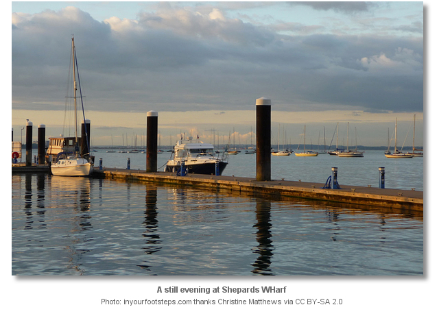
The marina now offers complete protection after the installation of a new breakwater that protects the inner harbour from northerly swell. However berths on the outer pontoon are subject to the wash from the constant comings and goings of the busy fairway. Safe access may be had in all reasonable conditions, day or night and at all stages of the tide.


Keyfacts for Shepards Wharf


Last modified
August 24th 2018 Summary
A completely protected location with safe access.Facilities


 pump out facilities")


Nature


Considerations


 +44 1983 297821
 shepards.chc@cowes.co.uk
 Ch.80
Ch.80Position and approaches

Expand to new tab or fullscreen
Haven position
 50° 45.582' N, 001° 17.564' W
This is at the southern end of the outer river side pontoon, by the entrance.


What are the key points of the approach?
The entry and the run-up thorough The Solent and Southampton Water are covered in
The Solent and Isle of Wight Coastal Overview. The approaches and run up the fairway are detailed in the Folly Inn
  entry.
The Solent and Isle of Wight
Coastal Overview. The approaches and run up the fairway are detailed in the Folly Inn entry.Not what you need?
Click the 'Next' and 'Previous' buttons to progress through neighbouring havens in a coastal 'clockwise' or 'anti-clockwise' sequence. Below are the ten nearest havens to Shepards Wharf for your convenience.
Ten nearest havens by straight line charted distance and bearing:
- Cowes Yacht Haven - 0.2 nautical miles NNW
- East Cowes Marina - 0.4 nautical miles S
- Cowes Harbour - 0.5 nautical miles NNW
- Osborne Bay - 1.5 nautical miles E
- Folly Inn - 1.6 nautical miles SSE
- Island Harbour Marine - 2.1 nautical miles SSE
- Thorness Bay - 2.9 nautical miles WSW
- Newport - 3.3 nautical miles S
- Wootton Creek (Fishbourne) - 3.3 nautical miles ESE
- Gull Island - 3.9 nautical miles WNW
These havens are ordered by straight line charted distance and bearing, and can be reordered by compass direction or coastal sequence:
- Cowes Yacht Haven - 0.2 miles NNW
- East Cowes Marina - 0.4 miles S
- Cowes Harbour - 0.5 miles NNW
- Osborne Bay - 1.5 miles E
- Folly Inn - 1.6 miles SSE
- Island Harbour Marine - 2.1 miles SSE
- Thorness Bay - 2.9 miles WSW
- Newport - 3.3 miles S
- Wootton Creek (Fishbourne) - 3.3 miles ESE
- Gull Island - 3.9 miles WNW


How to get in?

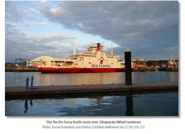
Shepards Wharf is located in the middle of the Isle of Wight’s principal port of Cowes. The town stands on both sides of the entrance to the River Medina and Cowes is located on the west bank facing the much smaller town of East Cowes on the east bank. Shepards Wharf is the second and smaller of the two marinas fronting the town of Cowes. As the town experiences 30,000 boat visitors a year 90 of its 130 possible berths are made available to visitors.
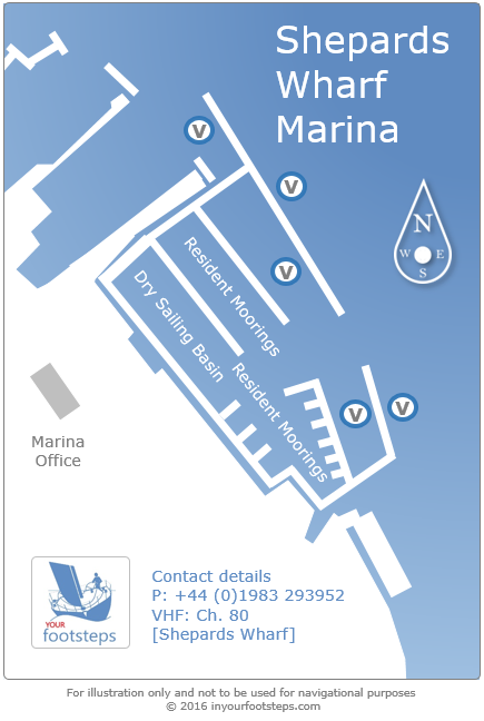
It is advisable to contact the marina in advance and make arrangements regarding an intended stay P: +44 1983 297821 VHF: Ch. 80 call sign [Shepards Wharf]. During large scale sailing events, such as Cowes Week, Round the Island Race and various other regattas, visitors should expect tariffs to increase as the marina tends to become overrun with demand. During these times it is essential to book well in advance to secure a berth.
 The approaches to Cowes and run the up the River Medina fairway are detailed in the Folly Inn entry. Berth as directed by the Cowes Yacht Haven marina office.
Why visit here?
The town of Cowes is fully introduced in the Cowes Harbour entry. Its two marinas of Shepards Wharf and Cowes Yacht Haven, situated in the heart of the sailing location that receives 30,000 boat visitors a years, are amongst the most visited berths in the UK. 
From a sailing perspective Shepards Wharf, as well as Cowes Yacht Haven, provide walk ashore access to the centre of Cowes and are ideal gateways to the island. They also provide very convenient ‘drop in’ locations should a problem emerge on a vessel that needs to be quickly attended to, or indeed for excellent provisioning.
What facilities are available?
Trinity Landing and Shepards Wharf Marina pontoons are fully serviced with water and power and the marina provides its visitors with showers, toilet and free wireless broadband internet access. Whitegates River Pontoons do not provide any services or walk ashore capability.Petrol and diesel are available from Lallow's Boatyard, between Cowes Yacht Haven and Shepards Wharf or more conveniently at Cowes Harbour Fuels, +44 1983 200716, south of the chain ferry. The Town Quay has scrubbing berths next to the Harbour Office and there is a slipway between Thetis Wharf and Shepards Wharf Marina. Cowes as a whole offers almost any conceivable marine services or facility a vessel could require. There is little in the marine world that can either be repaired or rebuild from first principals in Cowes. Having a population in excess of 10,000 it is also an excellent location for provisioning.
In transport terms Cowes is a gateway town for the Isle of Wight providing berths to two ferry services. Southern Vectis' route 1 is the main bus service in Cowes. Single decker buses branded Red 1 serve the Red Jet terminal, whilst route 1 double deckers serve the M&S Foodhall at Carvel Lane where the old Cowes railway station was situated. Both run to Newport to take travellers on to other island destinations. The Cowes Chain Ferry, locally known as the Floating Bridge connects the two towns of Cowes and East Cowes throughout the day. The old and discontinued rail link to and from the island's capital of Newport is now maintained as a cycle path.
Any security concerns?
The area has site wide CCTV coverage and there has never been an issue known to have occurred to a vessel moored at Shepards Wharf.With thanks to:
Michael Harpur S/Y Whistler. Photography Ray Stanton, David Dixon, Michael Harpur and an especial thank you to Ronald Saunders..jpg)


This video presents an aerial overview of Cowes and the entrance to the River Medina.
This video shows an aerial overview of the entrance and Shepards Wharf marina.
This video presents an aerial overview of Cowes, the entrance to the River Medina and both marinas during Cowes week.
This East Cowes Marina video presents the run up the river, in a RIB, from Prince Consort North Cardinal to East Cowes Marina.
About Shepards Wharf
The town of Cowes is fully introduced in the Cowes Harbour
entry. Its two marinas of Shepards Wharf and Cowes Yacht Haven, situated in the heart of the sailing location that receives 30,000 boat visitors a years, are amongst the most visited berths in the UK. From a sailing perspective Shepards Wharf, as well as Cowes Yacht Haven, provide walk ashore access to the centre of Cowes and are ideal gateways to the island. They also provide very convenient ‘drop in’ locations should a problem emerge on a vessel that needs to be quickly attended to, or indeed for excellent provisioning.
Other options in this area
Click the 'Next' and 'Previous' buttons to progress through neighbouring havens in a coastal 'clockwise' or 'anti-clockwise' sequence. Alternatively here are the ten nearest havens available in picture view:
Coastal clockwise:
Newport - 2 miles SIsland Harbour Marine - 1.3 miles SSE
Folly Inn - 1 miles SSE
East Cowes Marina - 0.2 miles S
Osborne Bay - 0.9 miles E
Coastal anti-clockwise:
Cowes Yacht Haven - 0.1 miles NNWCowes Harbour - 0.3 miles NNW
Thorness Bay - 1.8 miles WSW
Newtown River - 3 miles WSW
Newtown River Entrance - 3.1 miles WSW
Navigational pictures
These additional images feature in the 'How to get in' section of our detailed view for Shepards Wharf.


| Detail view | Off |
| Picture view | On |
This video presents an aerial overview of Cowes and the entrance to the River Medina.
This video shows an aerial overview of the entrance and Shepards Wharf marina.
This video presents an aerial overview of Cowes, the entrance to the River Medina and both marinas during Cowes week.
This East Cowes Marina video presents the run up the river, in a RIB, from Prince Consort North Cardinal to East Cowes Marina.
Add your review or comment:
Please log in to leave a review of this haven.
Please note eOceanic makes no guarantee of the validity of this information, we have not visited this haven and do not have first-hand experience to qualify the data. Although the contributors are vetted by peer review as practised authorities, they are in no way, whatsoever, responsible for the accuracy of their contributions. It is essential that you thoroughly check the accuracy and suitability for your vessel of any waypoints offered in any context plus the precision of your GPS. Any data provided on this page is entirely used at your own risk and you must read our legal page if you view data on this site. Free to use sea charts courtesy of Navionics.